Home > Europe > United Kingdom > Scotland > Western Isles > Lerwick
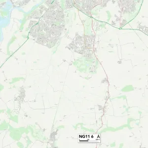
Nottingham NG11 8 Map

![]()
Wall Art and Photo Gifts from Map Marketing
Nottingham NG11 8 Map
Postcode Sector Map of Nottingham NG11 8
Media ID 19976062
Barton Lane Carew Road Cavell Close Chamberlain Close Clifton Lane College Drive Collingwood Close Fallow Close Farm Close Farnborough Road Glencoe Road Greencroft Haynes Close Holgate Hyde Close Jasmine Close Juniper Close Kipling Close Linden Avenue Manor Farm Lane Merlin Close Mimosa Close Nethergate Nottingham Orchard Close Osprey Close Parkland Close Porter Close Raleigh Close Richardson Close Shelley Avenue Smithy Close The Drift The Glen The Leys Village Road Wayne Close Whinfell Close Yew Tree Lane Maypole
FEATURES IN THESE COLLECTIONS
> Animals
> Fishes
> S
> Sturgeon
> Europe
> United Kingdom
> Scotland
> Aberdeenshire
> Huntly
> Europe
> United Kingdom
> Scotland
> Western Isles
> Lerwick
> Map Marketing
> Postcode Sector Maps
> NG - Nottingham
> Maps and Charts
> Related Images
MADE IN THE USA
Safe Shipping with 30 Day Money Back Guarantee
FREE PERSONALISATION*
We are proud to offer a range of customisation features including Personalised Captions, Color Filters and Picture Zoom Tools
SECURE PAYMENTS
We happily accept a wide range of payment options so you can pay for the things you need in the way that is most convenient for you
* Options may vary by product and licensing agreement. Zoomed Pictures can be adjusted in the Cart.