Home > Europe > United Kingdom > Scotland > Stirlingshire > Stirling
East Dunbartonshire G61 4 Map

![]()
Wall Art and Photo Gifts from Map Marketing
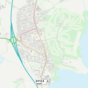
East Dunbartonshire G61 4 Map
Postcode Sector Map of East Dunbartonshire G61 4
Media ID 19971009
Abbotsford Road Baird Drive Burnside Burnside Court Campbell Drive Castlehill Road East Dunbartonshire Ettrick Drive Fairway Glenburn Road Golf View Grampian Way Greenside Place Kenilworth Crescent Lowther Avenue Nevis Road Park Crescent Paterson Place Pentland Place Rosslyn Road Scott Drive Southview St Andrews Drive St Andrews Way Station Road Stirling Drive The Poplars Thorn Drive Thorn Grove Thorn Road Westbourne Crescent Westbourne Drive Whitehill Road
FEATURES IN THESE COLLECTIONS
> Animals
> Mammals
> Muridae
> Peters Mouse
> Europe
> United Kingdom
> Scotland
> Fife
> St Andrews
> Europe
> United Kingdom
> Scotland
> Stirlingshire
> Stirling
> Map Marketing
> Postcode Sector Maps
> G - Glasgow
> Maps and Charts
> Related Images
MADE IN THE USA
Safe Shipping with 30 Day Money Back Guarantee
FREE PERSONALISATION*
We are proud to offer a range of customisation features including Personalised Captions, Color Filters and Picture Zoom Tools
SECURE PAYMENTS
We happily accept a wide range of payment options so you can pay for the things you need in the way that is most convenient for you
* Options may vary by product and licensing agreement. Zoomed Pictures can be adjusted in the Cart.