Home > Europe > United Kingdom > Wales > Mid Glamorgan > Aberdare
Bournemouth BH10 6 Map

![]()
Wall Art and Photo Gifts from Map Marketing
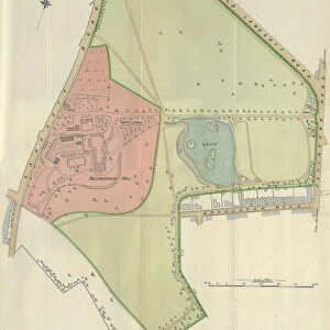
Bournemouth BH10 6 Map
Postcode Sector Map of Bournemouth BH10 6
Media ID 19965500
Aberdare Road Alderley Road Bournemouth Brierley Close Brierley Road Broadhurst Avenue Brockley Road Broughton Avenue Broughton Close Coppice View Dudley Gardens Dudley Road Frensham Close Glamis Avenue Orchard Grove Parkside Gardens Pinewood Avenue Pinewood Close Redhill Close Redhill Drive Romney Close Romney Road Sandy Way Thornley Road Wakefield Avenue Western Avenue
FEATURES IN THESE COLLECTIONS
> Animals
> Mammals
> Muridae
> Western Mouse
> Europe
> United Kingdom
> Wales
> Flintshire
> Broughton
> Europe
> United Kingdom
> Wales
> Mid Glamorgan
> Aberdare
> Map Marketing
> Postcode Sector Maps
> BH - Bournemouth
> Maps and Charts
> Related Images
MADE IN THE USA
Safe Shipping with 30 Day Money Back Guarantee
FREE PERSONALISATION*
We are proud to offer a range of customisation features including Personalised Captions, Color Filters and Picture Zoom Tools
SECURE PAYMENTS
We happily accept a wide range of payment options so you can pay for the things you need in the way that is most convenient for you
* Options may vary by product and licensing agreement. Zoomed Pictures can be adjusted in the Cart.