Home > Maps and Charts > Early Maps
Photographic Print : Map / Asia / Persia / Arabia


![]()
Photo Prints from Mary Evans Picture Library
Map / Asia / Persia / Arabia
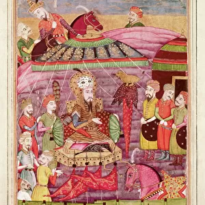
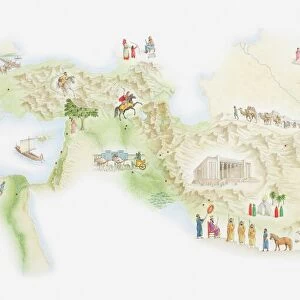
Map of Persia and Arabia
Mary Evans Picture Library makes available wonderful images created for people to enjoy over the centuries
Media ID 608859
© Mary Evans Picture Library 2015 - https://copyrighthub.org/s0/hub1/creation/maryevans/MaryEvansPictureID/10114194
14"x11" Photo Print
Introducing the captivating selection of Photographic Prints from Media Storehouse, featuring this intricately detailed map depicting Persia and Arabia from Mary Evans Prints Online. This exquisite piece transports you to ancient lands, where history and culture intertwine. The rich colors and sharp lines bring out the complexity of the region, making it an essential addition to your home or office decor. Delve into the fascinating history of Persia and Arabia with this stunning, high-quality print. Explore the vast deserts, bustling cities, and historic landmarks in a whole new light. Bring the mystery and allure of the Middle East into your space with this beautiful and authentic representation.
Photo prints are produced on Kodak professional photo paper resulting in timeless and breath-taking prints which are also ideal for framing. The colors produced are rich and vivid, with accurate blacks and pristine whites, resulting in prints that are truly timeless and magnificent. Whether you're looking to display your prints in your home, office, or gallery, our range of photographic prints are sure to impress. Dimensions refers to the size of the paper in inches.
Our Photo Prints are in a large range of sizes and are printed on Archival Quality Paper for excellent colour reproduction and longevity. They are ideal for framing (our Framed Prints use these) at a reasonable cost. Alternatives include cheaper Poster Prints and higher quality Fine Art Paper, the choice of which is largely dependant on your budget.
Estimated Image Size (if not cropped) is 25.7cm x 35.5cm (10.1" x 14")
Estimated Product Size is 27.9cm x 35.5cm (11" x 14")
These are individually made so all sizes are approximate
Artwork printed orientated as per the preview above, with portrait (vertical) orientation to match the source image.
EDITORS COMMENTS
This stunning historical print showcases a detailed map of Persia and Arabia from 1719, providing a fascinating glimpse into the geography of Asia during this time period. The intricate details and vibrant colors bring to life the vast expanse of these regions, highlighting important cities, rivers, and mountain ranges.
As we study this map, we are transported back in time to an era when cartography was both an art form and a scientific endeavor. Each line and symbol on the map tells a story of exploration, trade routes, and cultural exchange between different civilizations.
Persia and Arabia have long been at the crossroads of empires, serving as crucial hubs for trade between East and West. This map captures the strategic importance of these regions in shaping world history.
Whether you are a history buff or simply appreciate beautiful artwork, this print is sure to captivate your imagination. Display it in your home or office to spark conversations about ancient civilizations and the interconnectedness of our world.
Let this Map of Persia and Arabia serve as a reminder of how much we can learn from studying the past - not just about geography, but also about ourselves as human beings with a shared heritage.
MADE IN THE USA
Safe Shipping with 30 Day Money Back Guarantee
FREE PERSONALISATION*
We are proud to offer a range of customisation features including Personalised Captions, Color Filters and Picture Zoom Tools
SECURE PAYMENTS
We happily accept a wide range of payment options so you can pay for the things you need in the way that is most convenient for you
* Options may vary by product and licensing agreement. Zoomed Pictures can be adjusted in the Cart.