Canvas Print : Map / Asia / Persia / Arabia


![]()
Canvas Prints from Mary Evans Picture Library
Map / Asia / Persia / Arabia
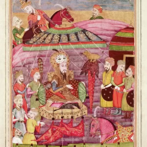
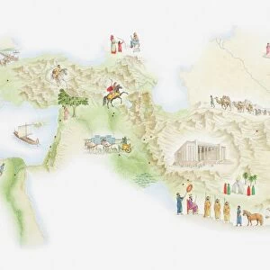
Map of Persia and Arabia
Mary Evans Picture Library makes available wonderful images created for people to enjoy over the centuries
Media ID 608859
© Mary Evans Picture Library 2015 - https://copyrighthub.org/s0/hub1/creation/maryevans/MaryEvansPictureID/10114194
20"x16" (51x41cm) Canvas Print
Introducing the stunning addition to our Media Storehouse Canvas Print collection: a captivating representation of Asia, focusing on the historic regions of Persia and Arabia. This exquisite print, sourced from the renowned Mary Evans Prints Online, transports you back in time with intricate details and vibrant colors. Ideal for adding a touch of world history and culture to your living space, this canvas print is not only a beautiful work of art but also a conversation starter. Bring the rich heritage of these ancient lands into your home with our premium quality, hand-stretched canvas print.
Delivered stretched and ready to hang our premium quality canvas prints are made from a polyester/cotton blend canvas and stretched over a 1.25" (32mm) kiln dried knot free wood stretcher bar. Packaged in a plastic bag and secured to a cardboard insert for safe transit.
Canvas Prints add colour, depth and texture to any space. Professionally Stretched Canvas over a hidden Wooden Box Frame and Ready to Hang
Estimated Product Size is 40.6cm x 50.8cm (16" x 20")
These are individually made so all sizes are approximate
Artwork printed orientated as per the preview above, with portrait (vertical) orientation to match the source image.
EDITORS COMMENTS
This stunning historical print showcases a detailed map of Persia and Arabia from 1719, providing a fascinating glimpse into the geography of Asia during this time period. The intricate details and vibrant colors bring to life the vast expanse of these regions, highlighting important cities, rivers, and mountain ranges.
As we study this map, we are transported back in time to an era when cartography was both an art form and a scientific endeavor. Each line and symbol on the map tells a story of exploration, trade routes, and cultural exchange between different civilizations.
Persia and Arabia have long been at the crossroads of empires, serving as crucial hubs for trade between East and West. This map captures the strategic importance of these regions in shaping world history.
Whether you are a history buff or simply appreciate beautiful artwork, this print is sure to captivate your imagination. Display it in your home or office to spark conversations about ancient civilizations and the interconnectedness of our world.
Let this Map of Persia and Arabia serve as a reminder of how much we can learn from studying the past - not just about geography, but also about ourselves as human beings with a shared heritage.
MADE IN THE USA
Safe Shipping with 30 Day Money Back Guarantee
FREE PERSONALISATION*
We are proud to offer a range of customisation features including Personalised Captions, Color Filters and Picture Zoom Tools
SECURE PAYMENTS
We happily accept a wide range of payment options so you can pay for the things you need in the way that is most convenient for you
* Options may vary by product and licensing agreement. Zoomed Pictures can be adjusted in the Cart.