Home > Asia > India > Maps
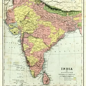
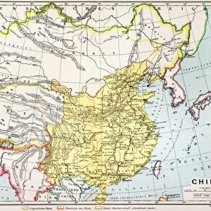
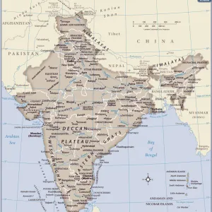
Photographic Print : Map / Asia / India C1870


![]()
Photo Prints from Mary Evans Picture Library
Map / Asia / India C1870
India, showing the various Presidencies under British rule
Mary Evans Picture Library makes available wonderful images created for people to enjoy over the centuries
Media ID 576624
© Mary Evans Picture Library 2015 - https://copyrighthub.org/s0/hub1/creation/maryevans/MaryEvansPictureID/10015675
14"x11" Photo Print
Discover the rich history of India during the British rule with our exquisite "Map / Asia / India C1870" print from Mary Evans Picture Library at Media Storehouse. This captivating antique map, sourced from Mary Evans Prints Online, offers a unique perspective into the various Presidencies that once formed the British Raj in India. The intricate details and vibrant colors bring the past to life, making this print an essential addition to any history enthusiast's collection or an elegant decor piece for your home or office. Experience the beauty and depth of the past with Media Storehouse's range of high-quality photographic prints.
Photo prints are produced on Kodak professional photo paper resulting in timeless and breath-taking prints which are also ideal for framing. The colors produced are rich and vivid, with accurate blacks and pristine whites, resulting in prints that are truly timeless and magnificent. Whether you're looking to display your prints in your home, office, or gallery, our range of photographic prints are sure to impress. Dimensions refers to the size of the paper in inches.
Our Photo Prints are in a large range of sizes and are printed on Archival Quality Paper for excellent colour reproduction and longevity. They are ideal for framing (our Framed Prints use these) at a reasonable cost. Alternatives include cheaper Poster Prints and higher quality Fine Art Paper, the choice of which is largely dependant on your budget.
Estimated Product Size is 27.9cm x 35.5cm (11" x 14")
These are individually made so all sizes are approximate
Artwork printed orientated as per the preview above, with landscape (horizontal) or portrait (vertical) orientation to match the source image.
FEATURES IN THESE COLLECTIONS
> Asia
> India
> Related Images
> Maps and Charts
> Early Maps
> Maps and Charts
> India
> Mary Evans Prints Online
> Maps
> Popular Themes
> Maps and Charts
EDITORS COMMENTS
This print of a historical map of India circa 1870 offers a fascinating glimpse into the country's past, specifically during the time when it was under British rule. The intricate details and borders on the map showcase the various Presidencies that existed at that time, providing valuable insight into the administrative divisions of India during this period.
The map not only serves as a visual representation of India's history but also highlights the influence and impact of British colonialism on the region. It is a reminder of a significant era in Indian history when political power was centralized in different regions under British control.
As we study this map, we are transported back in time to an era where boundaries were defined by colonial powers and cultures intersected in ways that shaped modern-day India. The meticulous craftsmanship and attention to detail on this map reflect both its historical significance and artistic value.
Overall, this print from Mary Evans Picture Library is not just a piece of art but also a valuable educational resource for those interested in exploring India's rich history and understanding how it has evolved over time under British rule.
MADE IN THE USA
Safe Shipping with 30 Day Money Back Guarantee
FREE PERSONALISATION*
We are proud to offer a range of customisation features including Personalised Captions, Color Filters and Picture Zoom Tools
SECURE PAYMENTS
We happily accept a wide range of payment options so you can pay for the things you need in the way that is most convenient for you
* Options may vary by product and licensing agreement. Zoomed Pictures can be adjusted in the Cart.