Jigsaw Puzzle > Asia > India > Maps
Jigsaw Puzzle : Map / Asia / India C1870


![]()
Jigsaw Puzzles from Mary Evans Picture Library
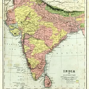
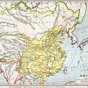
Map / Asia / India C1870
India, showing the various Presidencies under British rule
Mary Evans Picture Library makes available wonderful images created for people to enjoy over the centuries
Media ID 576624
© Mary Evans Picture Library 2015 - https://copyrighthub.org/s0/hub1/creation/maryevans/MaryEvansPictureID/10015675
Jigsaw Puzzle (520 Pieces)
Discover the rich history of India during the British Raj with our captivating jigsaw puzzle from the Media Storehouse collection. Featuring the intriguing image "Map / Asia / India C1870" by Mary Evans Picture Library from Mary Evans Prints Online, this puzzle invites you on a journey through time as you piece together the various Presidencies under British rule. With intricate details and vibrant colors, this historical puzzle is perfect for history buffs, puzzle enthusiasts, or anyone seeking a challenging and engaging activity. Immerse yourself in the past and bring this fascinating map to life - one piece at a time.
Made in the USA, 520-piece puzzles measure 16" x 20" (40.6 x 50.8 cm). Every puzzle is meticulously printed on glossy photo paper, which has a strong 1.33 mm thickness. Delivered in a black storage cardboard box, these puzzles are both stylish and practical. (Note: puzzles contain small parts and are not suitable for children under 3 years of age.)
Jigsaw Puzzles are an ideal gift for any occasion
Estimated Product Size is 40.5cm x 50.8cm (15.9" x 20")
These are individually made so all sizes are approximate
Artwork printed orientated as per the preview above, with landscape (horizontal) or portrait (vertical) orientation to match the source image.
FEATURES IN THESE COLLECTIONS
> Asia
> India
> Related Images
> Asia
> Related Images
> Maps and Charts
> Early Maps
> Maps and Charts
> India
> Maps and Charts
> Related Images
> Popular Themes
> Maps and Charts
> Mary Evans Prints Online
> Maps
EDITORS COMMENTS
This print of a historical map of India circa 1870 offers a fascinating glimpse into the country's past, specifically during the time when it was under British rule. The intricate details and borders on the map showcase the various Presidencies that existed at that time, providing valuable insight into the administrative divisions of India during this period.
The map not only serves as a visual representation of India's history but also highlights the influence and impact of British colonialism on the region. It is a reminder of a significant era in Indian history when political power was centralized in different regions under British control.
As we study this map, we are transported back in time to an era where boundaries were defined by colonial powers and cultures intersected in ways that shaped modern-day India. The meticulous craftsmanship and attention to detail on this map reflect both its historical significance and artistic value.
Overall, this print from Mary Evans Picture Library is not just a piece of art but also a valuable educational resource for those interested in exploring India's rich history and understanding how it has evolved over time under British rule.
MADE IN THE USA
Safe Shipping with 30 Day Money Back Guarantee
FREE PERSONALISATION*
We are proud to offer a range of customisation features including Personalised Captions, Color Filters and Picture Zoom Tools
SECURE PAYMENTS
We happily accept a wide range of payment options so you can pay for the things you need in the way that is most convenient for you
* Options may vary by product and licensing agreement. Zoomed Pictures can be adjusted in the Cart.