Jigsaw Puzzle > Universal Images Group (UIG) > Universal Images Group > Satellite and Aerial > Planet Observer 6
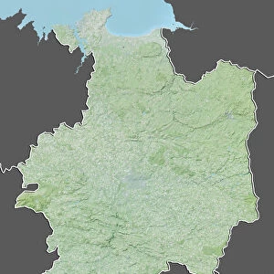
Jigsaw Puzzle : Departement of Ille-et-Vilaine, France, Satellite Image With Bump Effect


![]()
Jigsaw Puzzles From Universal Images Group (UIG)
Departement of Ille-et-Vilaine, France, Satellite Image With Bump Effect
Satellite view with bump effect of the departement of Ille-et-Vilaine in Brittany, France. It is bordered by the English Channel to the north. This image was compiled from data acquired by LANDSAT 5 & 7 satellites combined with elevation data
Universal Images Group (UIG) manages distribution for many leading specialist agencies worldwide
Media ID 9615581
© Planet Observer
Alsace Bas Rhin Geographical Border Relief Map Satellite View
Jigsaw Puzzle (520 Pieces)
Discover the beauty of Ille-et-Vilaine, France with our captivating jigsaw puzzle from Media Storehouse. This intricately designed puzzle features a satellite image of the departement with a unique bump effect, adding depth and texture to the stunning aerial view of Brittany's coastline. Explore the intricacies of the English Channel's border, and immerse yourself in the picturesque landscapes of this breathtaking region. Piece together the puzzle and bring the satellite image to life, making it a perfect activity for families or individuals seeking a challenging and rewarding experience.
Made in the USA, 520-piece puzzles measure 16" x 20" (40.6 x 50.8 cm). Every puzzle is meticulously printed on glossy photo paper, which has a strong 1.33 mm thickness. Delivered in a black storage cardboard box, these puzzles are both stylish and practical. (Note: puzzles contain small parts and are not suitable for children under 3 years of age.)
Jigsaw Puzzles are an ideal gift for any occasion
Estimated Product Size is 50.8cm x 40.5cm (20" x 15.9")
These are individually made so all sizes are approximate
Artwork printed orientated as per the preview above, with landscape (horizontal) or portrait (vertical) orientation to match the source image.
EDITORS COMMENTS
This print showcases the stunning beauty of the Departement of Ille-et-Vilaine in Brittany, France. With a unique bump effect, this satellite view provides a mesmerizing perspective on the region's topography and physical geography. Bordered by the majestic English Channel to the north, this image captures the essence of Ille-et-Vilaine's coastal charm. Compiled from data acquired by LANDSAT 5 & 7 satellites combined with elevation data, this print offers an intricate relief map that highlights every contour and feature of the land. The vibrant colors bring life to this aerial snapshot, showcasing nature's artistry at its finest. As you gaze upon this photograph, you can almost feel yourself transported into another world – a world where geographical borders fade away and pure natural wonder takes center stage. This is an invitation to explore every nook and cranny of Ille-et-Vilaine's diverse landscape - from rolling hills to serene valleys. With no people in sight, it allows you to immerse yourself fully in the tranquility and serenity that radiates from this picturesque scene. Whether you are an avid cartography enthusiast or simply appreciate breathtaking photography, this print will undoubtedly captivate your senses. Let your imagination soar as you delve into the depths of this satellite view masterpiece – a true testament to both technological advancements and Mother Nature's awe-inspiring creations.
MADE IN THE USA
Safe Shipping with 30 Day Money Back Guarantee
FREE PERSONALISATION*
We are proud to offer a range of customisation features including Personalised Captions, Color Filters and Picture Zoom Tools
SECURE PAYMENTS
We happily accept a wide range of payment options so you can pay for the things you need in the way that is most convenient for you
* Options may vary by product and licensing agreement. Zoomed Pictures can be adjusted in the Basket.