Jigsaw Puzzle > Maps and Charts > Related Images
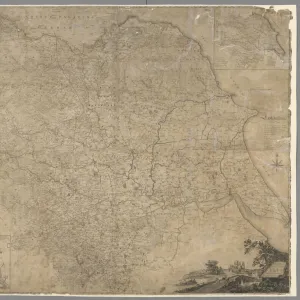
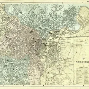
Jigsaw Puzzle : Map of the Southern Part of the West Riding of the County of York by Joseph Dickinson, 1750


![]()
Jigsaw Puzzles From Sheffield City Archives
Map of the Southern Part of the West Riding of the County of York by Joseph Dickinson, 1750
Scale 2 inches : 1 mile.Original at Sheffield City Archives: WWM/MP/95R
Sheffield City Archives and Local Studies Library has an unrivalled collection of images of Sheffield, England
Media ID 14046198
© Sheffield City Council
Jigsaw Puzzle (520 Pieces)
Discover the rich history of Yorkshire with our exquisite jigsaw puzzle from Media Storehouse. This intricately detailed puzzle features a rare 1750 map of the Southern Part of the West Riding of the County of York, originally created by Joseph Dickinson and held at Sheffield City Archives. With a stunning level of detail, this puzzle invites you to explore the intricacies of this historical map. Immerse yourself in the past as you piece together this beautiful puzzle, measuring scale 2 inches : 1 mile. A perfect gift for history enthusiasts, puzzle lovers, or anyone seeking a challenging and rewarding pastime.
Made in the USA, 520-piece puzzles measure 16" x 20" (40.6 x 50.8 cm). Every puzzle is meticulously printed on glossy photo paper, which has a strong 1.33 mm thickness. Delivered in a black storage cardboard box, these puzzles are both stylish and practical. (Note: puzzles contain small parts and are not suitable for children under 3 years of age.)
Jigsaw Puzzles are an ideal gift for any occasion
Estimated Product Size is 50.8cm x 40.5cm (20" x 15.9")
These are individually made so all sizes are approximate
Artwork printed orientated as per the preview above, with landscape (horizontal) or portrait (vertical) orientation to match the source image.
EDITORS COMMENTS
This print showcases a historical gem, the "Map of the Southern Part of the West Riding of the County of York" by Joseph Dickinson in 1750. With an impressive scale of 2 inches to 1 mile, this meticulously detailed map offers a fascinating glimpse into Yorkshire's past. Preserved at Sheffield City Archives under reference WWM/MP/95R, it stands as a testament to both Dickinson's cartographic expertise and the region's rich history. The map itself is a true work of art, depicting sprawling landscapes dotted with charming villages, winding rivers, and lush greenery. Every road and pathway is intricately illustrated, providing invaluable insight into transportation networks during that era. This visual treasure trove not only serves as an essential resource for historians but also captivates anyone who appreciates fine craftsmanship. Sheffield City Archives has done an exceptional job preserving this piece of history through this remarkable photo print. It allows viewers to admire every minute detail without compromising its integrity or commercializing its use. Whether you are researching local genealogy or simply curious about Yorkshire's heritage, this photograph provides an immersive experience that transports you back in time. In essence, this print from Sheffield City Archives encapsulates more than just geographical information; it encapsulates stories untold and memories long forgotten—a window into Yorkshire's vibrant past waiting to be explored by all those who appreciate the beauty and significance of historical cartography.
MADE IN THE USA
Safe Shipping with 30 Day Money Back Guarantee
FREE PERSONALISATION*
We are proud to offer a range of customisation features including Personalised Captions, Color Filters and Picture Zoom Tools
SECURE PAYMENTS
We happily accept a wide range of payment options so you can pay for the things you need in the way that is most convenient for you
* Options may vary by product and licensing agreement. Zoomed Pictures can be adjusted in the Basket.