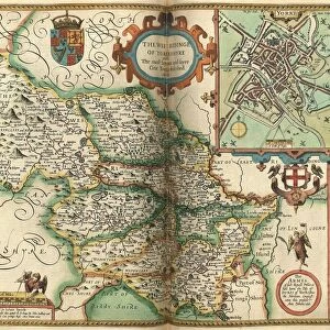
Jigsaw Puzzle : John Speeds map of Yorkshire, 1611


![]()
Jigsaw Puzzles From Sheffield City Archives
John Speeds map of Yorkshire, 1611
Image from Theatre of the Empire of Great Britaine presenting an exact geography of the Kingdomes of Ireland, Scotland, Ireland, and the Iles adioyning with The Shires, Hundreds, Cities and Shire Towns, within ye Kingdome of England, divided and described by John Speed (original at Sheffield Libraries: 914.2 SQ).
Note this image is of a genuine 400-year-old map from a tightly bound volume. It shows some wear and tear as well as the binding in the middle of the image
Sheffield City Archives and Local Studies Library has an unrivalled collection of images of Sheffield, England
Media ID 26401426
© Sheffield City Council - All Rights Reserved
Jigsaw Puzzle (520 Pieces)
Discover the rich history of Yorkshire with our exquisite jigsaw puzzle from the Media Storehouse collection. This intriguing puzzle features an authentic reproduction of John Speed's historic map of Yorkshire, dating back to 1611. Originally published in the Theatre of the Empire of Great Britaine, this map provides an exact geography of the shires, hundreds, and adjacent islands, offering a captivating glimpse into the past. Piece together this intricate puzzle and transport yourself back in time, immersing yourself in the beauty and detail of this remarkable historical artifact.
Made in the USA, 520-piece puzzles measure 16" x 20" (40.6 x 50.8 cm). Every puzzle is meticulously printed on glossy photo paper, which has a strong 1.33 mm thickness. Delivered in a black storage cardboard box, these puzzles are both stylish and practical. (Note: puzzles contain small parts and are not suitable for children under 3 years of age.)
Jigsaw Puzzles are an ideal gift for any occasion
Estimated Product Size is 50.8cm x 40.5cm (20" x 15.9")
These are individually made so all sizes are approximate
Artwork printed orientated as per the preview above, with landscape (horizontal) or portrait (vertical) orientation to match the source image.
EDITORS COMMENTS
This print showcases John Speed's map of Yorkshire, dating back to the year 1611. Extracted from his renowned work "Theatre of the Empire of Great Britaine" this image provides a fascinating glimpse into the exact geography of England during that era. Preserved within Sheffield Libraries, this genuine 400-year-old map offers a unique perspective on the Kingdoms of Ireland, Scotland, and Wales as well as their surrounding islands. While time has left its mark on this historical treasure, evident through signs of wear and tear, it only adds to its allure. The binding in the middle serves as a reminder that this map was once part of a tightly bound volume cherished by those seeking knowledge about their homeland or distant lands. As we gaze upon this remarkable artifact from Sheffield City Archives, we are transported back in time to an age where cartography was both an art form and a vital tool for exploration. It is awe-inspiring to imagine how John Speed meticulously crafted every detail with precision and dedication. Let us cherish this snapshot into history; let us appreciate the craftsmanship behind each stroke; let us marvel at how far our understanding of geography has evolved since then. This image invites us to delve deeper into our past while reminding us that even after centuries have passed, there is still much more to discover about our world.
MADE IN THE USA
Safe Shipping with 30 Day Money Back Guarantee
FREE PERSONALISATION*
We are proud to offer a range of customisation features including Personalised Captions, Color Filters and Picture Zoom Tools
SECURE PAYMENTS
We happily accept a wide range of payment options so you can pay for the things you need in the way that is most convenient for you
* Options may vary by product and licensing agreement. Zoomed Pictures can be adjusted in the Basket.