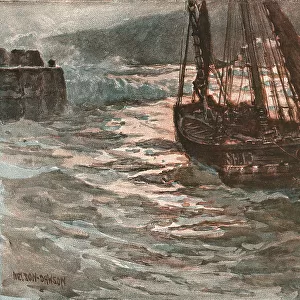
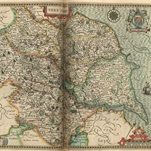
Jigsaw Puzzle : John Speeds map of Nottinghamshire, 1611


![]()
Jigsaw Puzzles From Sheffield City Archives
John Speeds map of Nottinghamshire, 1611
Image from Theatre of the Empire of Great Britaine presenting an exact geography of the Kingdomes of Ireland, Scotland, Ireland, and the Iles adioyning with The Shires, Hundreds, Cities and Shire Towns, within ye Kingdome of England, divided and described by John Speed (original at Sheffield Libraries: 914.2 SQ).
Note this image is of a genuine 400-year-old map from a tightly bound volume. It shows some wear and tear as well as the binding in the middle of the image
Sheffield City Archives and Local Studies Library has an unrivalled collection of images of Sheffield, England
Media ID 26401414
© Sheffield City Council - All Rights Reserved
Jigsaw Puzzle (520 Pieces)
Discover the rich history of Nottinghamshire with our captivating jigsaw puzzle from Media Storehouse. Featuring an intricately detailed image of John Speed's historic map of Nottinghamshire, dating back to 1611, this puzzle offers an engaging and educational experience. Originally from Sheffield City Archives, this map is part of the Theatre of the Empire of Great Britaine collection and showcases the shires, hundreds, and adjacent isles with precision. Immerse yourself in the past as you piece together this intricate 17th-century map, making it a perfect gift for history enthusiasts or anyone seeking a challenging puzzle.
Made in the USA, 520-piece puzzles measure 16" x 20" (40.6 x 50.8 cm). Every puzzle is meticulously printed on glossy photo paper, which has a strong 1.33 mm thickness. Delivered in a black storage cardboard box, these puzzles are both stylish and practical. (Note: puzzles contain small parts and are not suitable for children under 3 years of age.)
Jigsaw Puzzles are an ideal gift for any occasion
Estimated Product Size is 50.8cm x 40.5cm (20" x 15.9")
These are individually made so all sizes are approximate
Artwork printed orientated as per the preview above, with landscape (horizontal) or portrait (vertical) orientation to match the source image.
EDITORS COMMENTS
This print showcases John Speed's map of Nottinghamshire, dating back to 1611. Extracted from his renowned work "Theatre of the Empire of Great Britaine" this image provides a fascinating glimpse into the historical geography of England. Preserved within Sheffield Libraries, this genuine 400-year-old map offers an authentic connection to our past. Despite its age, the map exhibits signs of wear and tear that bear witness to its journey through time. The binding in the middle serves as a reminder that this artifact was once part of a tightly bound volume, treasured by those who sought knowledge and exploration. Its delicate state only adds to its allure and emphasizes the importance placed on preserving our heritage. John Speed's meticulous craftsmanship is evident in every detail depicted on this map. From shires and hundreds to cities and shire towns, he masterfully captures the intricate divisions within England's kingdom while also including neighboring Ireland and Scotland. This comprehensive representation highlights Speed's dedication to presenting an exact geography for future generations. As we gaze upon this remarkable piece of history, let us appreciate not only its aesthetic beauty but also recognize it as a testament to human curiosity and intellectual pursuit. May it serve as a reminder that maps are more than just geographical tools; they are gateways into understanding our collective pasts and shaping our futures with wisdom gained from those who came before us.
MADE IN THE USA
Safe Shipping with 30 Day Money Back Guarantee
FREE PERSONALISATION*
We are proud to offer a range of customisation features including Personalised Captions, Color Filters and Picture Zoom Tools
SECURE PAYMENTS
We happily accept a wide range of payment options so you can pay for the things you need in the way that is most convenient for you
* Options may vary by product and licensing agreement. Zoomed Pictures can be adjusted in the Basket.