Jigsaw Puzzle > North America > Mexico > Maps
Jigsaw Puzzle : United States territory in 1830


![]()
Jigsaw Puzzles From North Wind
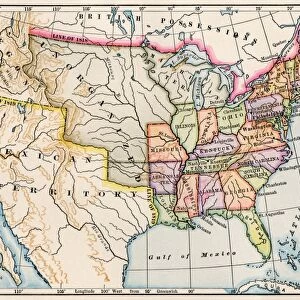
United States territory in 1830
Map of the United States in 1830.
Printed color lithograph
North Wind Picture Archives brings history to life with stock images and hand-colored illustrations
Media ID 5877438
© North Wind Picture Archives
1830s America Frontier Mexico Oregon Oregon Territory State Territory 1830
Jigsaw Puzzle (1014 Pieces)
Step back in time with Media Storehouse's Jigsaw Puzzle featuring a captivating image of United States territory in 1830, from North Wind Picture Archives. This intricately detailed, printed color lithograph puzzle offers an educational and enjoyable experience as you piece together the history of the United States. Immerse yourself in the past as you explore the borders and territories that shaped our nation's history. A perfect activity for history enthusiasts, families, or anyone seeking a challenging mental workout. Engage in a captivating journey through time with our United States in 1830 puzzle.
Made in the USA, 1014-piece puzzles measure 20" x 30" (50.8 x 76.2 cm). Every puzzle is meticulously printed on glossy photo paper, which has a strong 1.33 mm thickness. Delivered in a black storage cardboard box, these puzzles are both stylish and practical. (Note: puzzles contain small parts and are not suitable for children under 3 years of age.)
Jigsaw Puzzles are an ideal gift for any occasion
Estimated Product Size is 76cm x 50.8cm (29.9" x 20")
These are individually made so all sizes are approximate
Artwork printed orientated as per the preview above, with landscape (horizontal) orientation to match the source image.
FEATURES IN THESE COLLECTIONS
> Maps and Charts
> Related Images
> North America
> Mexico
> Maps
> North America
> Mexico
> Related Images
> North Wind Picture Archives
> American history
EDITORS COMMENTS
This vintage print showcases the United States territory in 1830, offering a glimpse into the rich history and vast expanse of this great nation. The map, printed with vibrant colors through lithography, captures the essence of American heritage and tradition. In this 19th-century illustration, we witness the frontier spirit that defined America during this era. From coast to coast, it depicts the unorganized public lands and territories that were yet to be fully explored and settled. The map highlights significant regions such as Oregon Territory and Mexico, which played pivotal roles in shaping America's expansion. As we delve into its intricate details, we are transported back in time to an era when North America was still being discovered. This artful representation not only serves as a historical document but also evokes a sense of adventure and curiosity about our past. Through this print from North Wind Picture Archives, we can appreciate how far our country has come since those early days. It reminds us of the pioneers who paved the way for progress while honoring their legacy. Whether you are a history enthusiast or simply intrigued by American roots, this stunning piece offers an opportunity to connect with our shared heritage. Let it inspire you to explore further into the stories hidden within each corner of these once-uncharted territories.
MADE IN THE USA
Safe Shipping with 30 Day Money Back Guarantee
FREE PERSONALISATION*
We are proud to offer a range of customisation features including Personalised Captions, Color Filters and Picture Zoom Tools
SECURE PAYMENTS
We happily accept a wide range of payment options so you can pay for the things you need in the way that is most convenient for you
* Options may vary by product and licensing agreement. Zoomed Pictures can be adjusted in the Basket.