Jigsaw Puzzle > Europe > United Kingdom > England > London > Transport > Railway
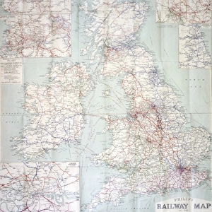
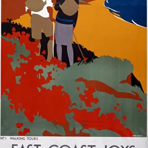
Jigsaw Puzzle : Railway Map of England


![]()
Jigsaw Puzzles from Mary Evans Picture Library
Railway Map of England
London & North Western Railway Co rail map of England, 1899 Date: 1899
Mary Evans Picture Library makes available wonderful images created for people to enjoy over the centuries
Media ID 7402325
© Mary Evans Picture Library 2015 - https://copyrighthub.org/s0/hub1/creation/maryevans/MaryEvansPictureID/10473989
Jigsaw Puzzle (520 Pieces)
Discover the intriguing history of England's railways with our captivating jigsaw puzzle from Media Storehouse. This beautifully detailed puzzle features a vintage Railway Map of England from the London & North Western Railway Co, dated 1899. Originally sourced from Mary Evans Prints Online, this puzzle brings to life the intricate network of rail lines that shaped the country's transportation system over a century ago. Immerse yourself in the past as you piece together this intriguing puzzle, perfect for railway enthusiasts, history buffs, or anyone in search of a challenging and rewarding pastime.
Made in the USA, 520-piece puzzles measure 16" x 20" (40.6 x 50.8 cm). Every puzzle is meticulously printed on glossy photo paper, which has a strong 1.33 mm thickness. Delivered in a black storage cardboard box, these puzzles are both stylish and practical. (Note: puzzles contain small parts and are not suitable for children under 3 years of age.)
Jigsaw Puzzles are an ideal gift for any occasion
Estimated Product Size is 40.5cm x 50.8cm (15.9" x 20")
These are individually made so all sizes are approximate
Artwork printed orientated as per the preview above, with landscape (horizontal) or portrait (vertical) orientation to match the source image.
FEATURES IN THESE COLLECTIONS
> Animals
> Mammals
> Muridae
> Western Mouse
> Europe
> United Kingdom
> England
> London
> Related Images
> Europe
> United Kingdom
> England
> London
> Transport
> Railway
> Europe
> United Kingdom
> England
> Maps
> Europe
> United Kingdom
> England
> Posters
> Europe
> United Kingdom
> England
> Railways
> Europe
> United Kingdom
> England
> Related Images
> Maps and Charts
> Related Images
> Popular Themes
> Railway Posters
> Mary Evans Prints Online
> National Archives
EDITORS COMMENTS
This stunning vintage print showcases the intricate Railway Map of England from 1899, specifically highlighting the London & North Western Railway Co rail network. The detailed map provides a fascinating glimpse into the extensive train routes that crisscrossed through England during the 19th century.
The advertisement for this railway company is a true testament to the advancements in transportation and infrastructure during this time period. The carefully drawn lines and labels on the map illustrate just how interconnected England was by rail, allowing for easier travel and trade across the country.
As you study this piece of history, you can't help but marvel at the sheer scale of the English railway system in 1899. It's a reminder of how far we've come in terms of modern transportation and communication networks.
Whether you're a history buff, a train enthusiast, or simply appreciate beautiful vintage prints, this Railway Map of England is sure to captivate your imagination. Let yourself be transported back in time to an era when steam trains ruled the tracks and explore all that this incredible map has to offer.
MADE IN THE USA
Safe Shipping with 30 Day Money Back Guarantee
FREE PERSONALISATION*
We are proud to offer a range of customisation features including Personalised Captions, Color Filters and Picture Zoom Tools
SECURE PAYMENTS
We happily accept a wide range of payment options so you can pay for the things you need in the way that is most convenient for you
* Options may vary by product and licensing agreement. Zoomed Pictures can be adjusted in the Cart.