Jigsaw Puzzle > Maps and Charts > Early Maps
Jigsaw Puzzle : Atlantis / Map


![]()
Jigsaw Puzzles from Mary Evans Picture Library
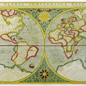
Atlantis / Map
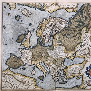
Map showing Atlantis during the period of its decadence
Mary Evans Picture Library makes available wonderful images created for people to enjoy over the centuries
Media ID 577910
© Mary Evans Picture Library 2015 - https://copyrighthub.org/s0/hub1/creation/maryevans/MaryEvansPictureID/10018416
1896 Atlantis Decadence Folk Lore Mythical Places
Jigsaw Puzzle (520 Pieces)
Discover the captivating mystery of ancient Atlantis with our exquisite jigsaw puzzle from the Media Storehouse collection, featuring the enchanting "Atlantis / Map" image from Mary Evans Picture Library. This intricately detailed puzzle, drawn from Mary Evans Prints Online, transports you back in time to the legendary city during its period of decadence. With rich colors and intricate lines, each piece of this jigsaw puzzle is a piece of history waiting to be discovered. Unleash your inner explorer and embark on an adventure to uncover the secrets of Atlantis, one puzzle piece at a time.
Made in the USA, 520-piece puzzles measure 16" x 20" (40.6 x 50.8 cm). Every puzzle is meticulously printed on glossy photo paper, which has a strong 1.33 mm thickness. Delivered in a black storage cardboard box, these puzzles are both stylish and practical. (Note: puzzles contain small parts and are not suitable for children under 3 years of age.)
Jigsaw Puzzles are an ideal gift for any occasion
Estimated Product Size is 50.8cm x 40.5cm (20" x 15.9")
These are individually made so all sizes are approximate
Artwork printed orientated as per the preview above, with landscape (horizontal) or portrait (vertical) orientation to match the source image.
FEATURES IN THESE COLLECTIONS
> Maps and Charts
> Early Maps
> Maps and Charts
> Related Images
> Mary Evans Prints Online
> Maps
EDITORS COMMENTS
This stunning print from Mary Evans Picture Library captures a detailed map of Atlantis during the period of its decadence. The intricate design showcases the mythical city in all its historical glory, offering a glimpse into the folklore and history surrounding this legendary civilization.
Dating back to 1896, this map provides a unique perspective on one of the most enigmatic places in ancient mythology. As we study the various landmarks and structures depicted on the map, we can't help but be drawn into the mystery and allure of Atlantis.
The artist's attention to detail is evident in every corner of this print, from the faded borders to the intricate illustrations that bring this mythical city to life. It's as if we are peering through a window into another time, witnessing firsthand the grandeur and eventual decline of Atlantis.
As we contemplate this image, we are reminded of how stories and legends have shaped our understanding of history. The tale of Atlantis continues to captivate us centuries after it was first told, serving as a reminder of humanity's endless fascination with lost civilizations and ancient mysteries.
Whether you're a history buff or simply appreciate beautiful artwork, this print is sure to spark your imagination and transport you to a world where anything is possible.
MADE IN THE USA
Safe Shipping with 30 Day Money Back Guarantee
FREE PERSONALISATION*
We are proud to offer a range of customisation features including Personalised Captions, Color Filters and Picture Zoom Tools
SECURE PAYMENTS
We happily accept a wide range of payment options so you can pay for the things you need in the way that is most convenient for you
* Options may vary by product and licensing agreement. Zoomed Pictures can be adjusted in the Cart.