Jigsaw Puzzle : Maps / World / Strabo


![]()
Jigsaw Puzzles from Mary Evans Picture Library
Maps / World / Strabo
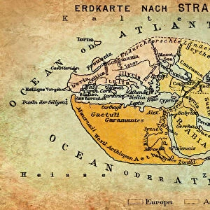
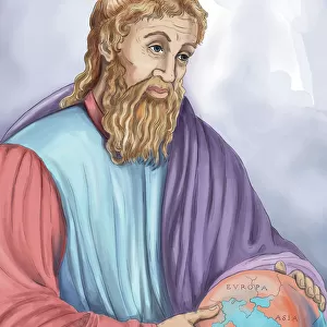
The world as known to Strabo
Mary Evans Picture Library makes available wonderful images created for people to enjoy over the centuries
Media ID 581520
© Mary Evans Picture Library 2015 - https://copyrighthub.org/s0/hub1/creation/maryevans/MaryEvansPictureID/10027529
Jigsaw Puzzle (520 Pieces)
Discover the captivating world of antiquity with our exquisite collection of jigsaw puzzles from Media Storehouse, featuring the mesmerizing image "Maps / World / Strabo" by Mary Evans Picture Library from Mary Evans Prints Online. This intriguing puzzle transports you back in time, revealing the world as it was known to the renowned ancient geographer, Strabo. Assemble the intricately detailed pieces to unveil the vast landscapes, bustling cities, and unexplored territories depicted in this stunning representation. Immerse yourself in the rich history and culture of ancient civilizations as you piece together this captivating puzzle, a perfect activity for history enthusiasts, puzzle lovers, or anyone seeking an engaging and educational pastime.
Made in the USA, 520-piece puzzles measure 16" x 20" (40.6 x 50.8 cm). Every puzzle is meticulously printed on glossy photo paper, which has a strong 1.33 mm thickness. Delivered in a black storage cardboard box, these puzzles are both stylish and practical. (Note: puzzles contain small parts and are not suitable for children under 3 years of age.)
Jigsaw Puzzles are an ideal gift for any occasion
Estimated Product Size is 50.8cm x 40.5cm (20" x 15.9")
These are individually made so all sizes are approximate
Artwork printed orientated as per the preview above, with landscape (horizontal) or portrait (vertical) orientation to match the source image.
EDITORS COMMENTS
This print from Mary Evans Picture Library showcases a historical map titled "Maps / World / Strabo (The world as known to Strabo)." Dating back to around 30 AD, this ancient depiction offers a fascinating glimpse into the geographical knowledge of the time.
As one of the most renowned geographers and historians of antiquity, Strabo's interpretation of the world is both insightful and intriguing. The intricate details and markings on this map provide valuable insights into how people in that era perceived their surroundings.
From Europe to Asia, Africa to the Americas, this map illustrates the extent of human exploration and understanding during Strabo's lifetime. It serves as a reminder of our ancestors' curiosity about distant lands and their desire to chart unknown territories.
The craftsmanship evident in this piece is truly remarkable, showcasing not only an accurate representation of geographical features but also artistic flair. Each line drawn with precision tells a story of discovery and adventure.
For history enthusiasts or those with an appreciation for cartography, this print is sure to spark curiosity and wonder about how our world has evolved over centuries. It stands as a testament to humanity's enduring quest for knowledge and understanding of our planet.
MADE IN THE USA
Safe Shipping with 30 Day Money Back Guarantee
FREE PERSONALISATION*
We are proud to offer a range of customisation features including Personalised Captions, Color Filters and Picture Zoom Tools
SECURE PAYMENTS
We happily accept a wide range of payment options so you can pay for the things you need in the way that is most convenient for you
* Options may vary by product and licensing agreement. Zoomed Pictures can be adjusted in the Cart.