Jigsaw Puzzle > Arts > Artists > O > Oceanic Oceanic
Jigsaw Puzzle : Maps / World / Currents


![]()
Jigsaw Puzzles from Mary Evans Picture Library
Maps / World / Currents
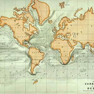
World map of the ocean currents
Mary Evans Picture Library makes available wonderful images created for people to enjoy over the centuries
Media ID 592843
© Mary Evans Picture Library 2015 - https://copyrighthub.org/s0/hub1/creation/maryevans/MaryEvansPictureID/10042276
Jigsaw Puzzle (1014 Pieces)
Discover the captivating world of ocean currents with our latest addition to the Media Storehouse Jigsaw Puzzles collection, featuring the stunning "Maps / World / Currents" image from Mary Evans Picture Library. This intricately detailed puzzle showcases a mesmerizing world map illustrating the complex patterns of ocean currents. Ideal for puzzle enthusiasts and geography lovers alike, this challenging jigsaw puzzle promises hours of engaging entertainment as you piece together the intricate waterways and continents. Immerse yourself in the wonders of our planet's hydrosphere and unlock a newfound appreciation for the natural forces that shape our world.
Made in the USA, 1014-piece puzzles measure 20" x 30" (50.8 x 76.2 cm). Every puzzle is meticulously printed on glossy photo paper, which has a strong 1.33 mm thickness. Delivered in a black storage cardboard box, these puzzles are both stylish and practical. (Note: puzzles contain small parts and are not suitable for children under 3 years of age.)
Jigsaw Puzzles are an ideal gift for any occasion
Estimated Product Size is 76cm x 50.8cm (29.9" x 20")
These are individually made so all sizes are approximate
Artwork printed orientated as per the preview above, with landscape (horizontal) orientation to match the source image.
FEATURES IN THESE COLLECTIONS
> Arts
> Artists
> O
> Oceanic Oceanic
> Maps and Charts
> Early Maps
> Maps and Charts
> Related Images
> Maps and Charts
> World
EDITORS COMMENTS
This print from Mary Evans Picture Library showcases a stunning world map of ocean currents, dating back to the late 19th century. The intricate details and historical significance of this map are truly mesmerizing, offering a glimpse into the way our ancestors navigated the vast seas.
As we gaze upon this piece, we are transported back in time to an era where exploration and discovery were at the forefront of human endeavors. The delicate lines and patterns on the map reveal the complex network of currents that crisscrossed the oceans, shaping trade routes and influencing maritime travel.
The beauty of this print lies not only in its visual appeal but also in its educational value. It serves as a reminder of how interconnected our world truly is, with currents acting as invisible highways that connect distant shores and shape ecosystems.
Whether you're a history buff or simply appreciate fine art, this world map of ocean currents is sure to captivate your imagination. It's a testament to human ingenuity and curiosity, reminding us of our enduring quest to understand and conquer the great unknown that lies beyond our shores.
MADE IN THE USA
Safe Shipping with 30 Day Money Back Guarantee
FREE PERSONALISATION*
We are proud to offer a range of customisation features including Personalised Captions, Color Filters and Picture Zoom Tools
SECURE PAYMENTS
We happily accept a wide range of payment options so you can pay for the things you need in the way that is most convenient for you
* Options may vary by product and licensing agreement. Zoomed Pictures can be adjusted in the Cart.