Jigsaw Puzzle > Europe > United Kingdom > England > London > Boroughs > City of Westminster
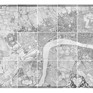
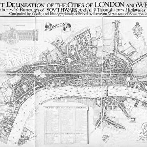
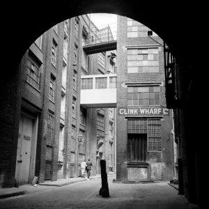
Jigsaw Puzzle : Map of Westminster, 1593


![]()
Jigsaw Puzzles from Mary Evans Picture Library
Map of Westminster, 1593
Map of Westminster, London, 1593
Mary Evans Picture Library makes available wonderful images created for people to enjoy over the centuries
Media ID 570810
© Mary Evans Picture Library 2015 - https://copyrighthub.org/s0/hub1/creation/maryevans/MaryEvansPictureID/10001810
Jigsaw Puzzle (520 Pieces)
Discover the rich history of London with our exquisite jigsaw puzzle from the Media Storehouse collection, featuring the captivating "Map of Westminster, 1593" by Mary Evans Picture Library from Mary Evans Prints Online. This intricately detailed puzzle transports you back in time to the bustling streets of Tudor-era London. Explore the labyrinth of cobblestone streets, grand palaces, and historic landmarks as you piece together this stunning representation of Westminster, meticulously recreated for your puzzling pleasure. Immerse yourself in the past and indulge in the joy of discovery with this captivating puzzle.
Made in the USA, 520-piece puzzles measure 16" x 20" (40.6 x 50.8 cm). Every puzzle is meticulously printed on glossy photo paper, which has a strong 1.33 mm thickness. Delivered in a black storage cardboard box, these puzzles are both stylish and practical. (Note: puzzles contain small parts and are not suitable for children under 3 years of age.)
Jigsaw Puzzles are an ideal gift for any occasion
Estimated Product Size is 50.8cm x 40.5cm (20" x 15.9")
These are individually made so all sizes are approximate
Artwork printed orientated as per the preview above, with landscape (horizontal) or portrait (vertical) orientation to match the source image.
FEATURES IN THESE COLLECTIONS
> Arts
> Landscape paintings
> Waterfall and river artworks
> River artworks
> Europe
> United Kingdom
> England
> London
> Boroughs
> City of Westminster
> Europe
> United Kingdom
> England
> London
> Related Images
> Europe
> United Kingdom
> England
> London
> River Thames
> Europe
> United Kingdom
> England
> Maps
> Europe
> United Kingdom
> England
> Posters
> Europe
> United Kingdom
> England
> Related Images
> Europe
> United Kingdom
> England
> Rivers
> Europe
> United Kingdom
> England
> Westminster
> Maps and Charts
> Early Maps
EDITORS COMMENTS
This print of the "Map of Westminster, 1593" takes us back in time to the bustling streets and winding riverbanks of London in the 16th century. The intricate details and historical significance captured in this map offer a glimpse into the rich history of Westminster, showcasing its importance as a political and cultural hub during this era.
As we study the layout of the city, with its narrow alleyways, grand palaces, and iconic landmarks along the Thames River, we can't help but marvel at how much has changed over the centuries. From St. James's Palace to Westminster Abbey, each building tells a story of England's past and adds layers to our understanding of this vibrant metropolis.
The meticulous craftsmanship displayed in this map is a testament to the skill and dedication of cartographers from centuries ago. Their ability to capture every street corner and architectural detail with such precision is truly remarkable.
Whether you're a history buff or simply appreciate fine artistry, this print is sure to spark your curiosity and transport you back in time to explore the sights and sounds of Elizabethan London. It serves as a reminder that even as cities evolve and grow, their roots remain firmly planted in their storied pasts.
MADE IN THE USA
Safe Shipping with 30 Day Money Back Guarantee
FREE PERSONALISATION*
We are proud to offer a range of customisation features including Personalised Captions, Color Filters and Picture Zoom Tools
SECURE PAYMENTS
We happily accept a wide range of payment options so you can pay for the things you need in the way that is most convenient for you
* Options may vary by product and licensing agreement. Zoomed Pictures can be adjusted in the Cart.