Jigsaw Puzzle > Maps and Charts > Early Maps
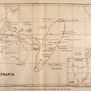
Jigsaw Puzzle : Lemuria Map


![]()
Jigsaw Puzzles from Mary Evans Picture Library
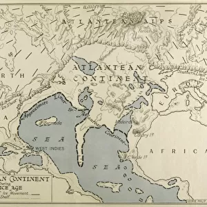
Lemuria Map
A map of Lemuria at its greatest extent
Mary Evans Picture Library makes available wonderful images created for people to enjoy over the centuries
Media ID 581225
© Mary Evans Picture Library 2015 - https://copyrighthub.org/s0/hub1/creation/maryevans/MaryEvansPictureID/10026655
Extent Folk Lore Greatest Mythical Places Lemuria
Jigsaw Puzzle (520 Pieces)
Discover the captivating world of ancient civilizations with our Lemuria Map jigsaw puzzle from the Media Storehouse collection, brought to you by Mary Evans Picture Library from Mary Evans Prints Online. This intriguing puzzle depicts a mesmerizing map of Lemuria, believed to be the legendary sunken continent in the Indian Ocean. With its detailed illustration of the landmass at its greatest extent, this puzzle promises an engaging and educational experience for puzzle enthusiasts of all ages. Unravel the mysteries of this lost world and transport yourself to a time long past. Puzzle pieces are made from high-quality, premium board for a superior fit and finish. Bring history to life in your home with this striking and intriguing jigsaw puzzle.
Made in the USA, 520-piece puzzles measure 16" x 20" (40.6 x 50.8 cm). Every puzzle is meticulously printed on glossy photo paper, which has a strong 1.33 mm thickness. Delivered in a black storage cardboard box, these puzzles are both stylish and practical. (Note: puzzles contain small parts and are not suitable for children under 3 years of age.)
Jigsaw Puzzles are an ideal gift for any occasion
Estimated Product Size is 50.8cm x 40.5cm (20" x 15.9")
These are individually made so all sizes are approximate
Artwork printed orientated as per the preview above, with landscape (horizontal) or portrait (vertical) orientation to match the source image.
FEATURES IN THESE COLLECTIONS
> Maps and Charts
> Early Maps
> Maps and Charts
> Related Images
EDITORS COMMENTS
This stunning print of the Lemuria Map showcases the mythical and historical significance of this lost continent. Created in 1904, this map depicts Lemuria at its greatest extent, offering a glimpse into the folklore and legends surrounding this mysterious land.
Lemuria is a place shrouded in mystery and intrigue, with tales of advanced civilizations and ancient cultures that once thrived there. The intricate details on this map bring to life the various places and landmarks that are said to have existed on Lemuria.
As you study this map, you can't help but be captivated by the rich history and lore associated with Lemuria. From Mu to its greatest extent, every corner of this mythical land is filled with stories waiting to be discovered.
Mary Evans Picture Library has truly captured the essence of Lemuria through this beautiful print. It serves as a reminder of our fascination with lost civilizations and unexplored territories, sparking our imagination and curiosity about what lies beyond our known world.
Whether you're a history buff or simply intrigued by myths and legends, this Lemuria Map is sure to transport you to a realm where anything is possible. Let yourself get lost in the enchanting world of Lemuria as you explore every inch of this map.
MADE IN THE USA
Safe Shipping with 30 Day Money Back Guarantee
FREE PERSONALISATION*
We are proud to offer a range of customisation features including Personalised Captions, Color Filters and Picture Zoom Tools
SECURE PAYMENTS
We happily accept a wide range of payment options so you can pay for the things you need in the way that is most convenient for you
* Options may vary by product and licensing agreement. Zoomed Pictures can be adjusted in the Cart.