Jigsaw Puzzle > Asia > Palestine > Maps
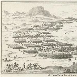
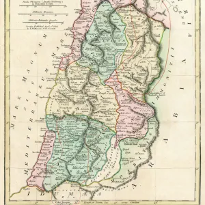
Jigsaw Puzzle : 12 Tribes of Israel


![]()
Jigsaw Puzzles from Mary Evans Picture Library
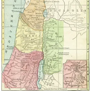
12 Tribes of Israel
The distribution of the twelve Tribes of Israel; note also a small strip of coastline occupied by the Philistines
Mary Evans Picture Library makes available wonderful images created for people to enjoy over the centuries
Media ID 605339
© Mary Evans Picture Library 2015 - https://copyrighthub.org/s0/hub1/creation/maryevans/MaryEvansPictureID/10052652
Coast Line Distribution Israel Maps Note Occupied Palestine Philistines Strip Tribes Twelve
Jigsaw Puzzle (520 Pieces)
Discover the rich history and intricate connections of the Twelve Tribes of Israel with our captivating jigsaw puzzle from Media Storehouse and Mary Evans Picture Library. This beautiful puzzle depicts a detailed and evocative image of "The Twelve Tribes of Israel" by Mary Evans Prints Online. In this captivating scene, observe the distribution of the twelve tribes, each represented by their unique symbols, alongside a small strip of coastline occupied by the Philistines. Connect the dots and piece together this intricate puzzle to reveal the fascinating story of the Israelites, their tribes, and their ancient enemies. Immerse yourself in the history and culture of the ancient world with this stimulating and engaging puzzle from Media Storehouse.
Made in the USA, 520-piece puzzles measure 16" x 20" (40.6 x 50.8 cm). Every puzzle is meticulously printed on glossy photo paper, which has a strong 1.33 mm thickness. Delivered in a black storage cardboard box, these puzzles are both stylish and practical. (Note: puzzles contain small parts and are not suitable for children under 3 years of age.)
Jigsaw Puzzles are an ideal gift for any occasion
Estimated Product Size is 50.8cm x 40.5cm (20" x 15.9")
These are individually made so all sizes are approximate
Artwork printed orientated as per the preview above, with landscape (horizontal) or portrait (vertical) orientation to match the source image.
FEATURES IN THESE COLLECTIONS
> Asia
> Israel
> Related Images
> Asia
> Palestine
> Related Images
> Maps and Charts
> Early Maps
> Maps and Charts
> Related Images
EDITORS COMMENTS
This stunning historical print showcases the distribution of the twelve Tribes of Israel, with a small strip of coastline also occupied by the Philistines. The intricate map provides a glimpse into the ancient history and geography of Palestine, highlighting the territories belonging to each tribe.
The detailed depiction allows viewers to trace the boundaries and locations of each tribe, offering valuable insight into how land was divided among the descendants of Jacob. The presence of the Philistines along the coast serves as a reminder of neighboring civilizations and potential conflicts that may have arisen during this time period.
Mary Evans Picture Library has curated an exceptional collection that brings history to life through visual representations like this one. The precision and accuracy in mapping out these territories provide a deeper understanding of biblical narratives and ancient civilizations.
Whether you are a history enthusiast, scholar, or simply appreciate fine art, this print offers a unique perspective on the Twelve Tribes of Israel and their surroundings. It is not just a map but a window into centuries past, inviting us to explore and learn from our rich cultural heritage.
MADE IN THE USA
Safe Shipping with 30 Day Money Back Guarantee
FREE PERSONALISATION*
We are proud to offer a range of customisation features including Personalised Captions, Color Filters and Picture Zoom Tools
SECURE PAYMENTS
We happily accept a wide range of payment options so you can pay for the things you need in the way that is most convenient for you
* Options may vary by product and licensing agreement. Zoomed Pictures can be adjusted in the Cart.