Jigsaw Puzzle > Europe > United Kingdom > Scotland > Scottish Borders > Selkirk
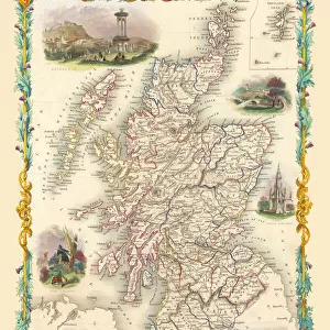
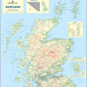
Jigsaw Puzzle : Old Map of the County of Selkirk from the Philips Handy Atlas of 1882


![]()
Jigsaw Puzzles from MapSeeker
Old Map of the County of Selkirk from the Philips Handy Atlas of 1882
PHA028
Welcome to the Mapseeker Image library and enter an historic gateway to one of the largest on-line collections of Historic Maps, Nostalgic Views, Vista's and Panorama's from a World gone by.
Media ID 20348191
County Map County Map Of Scotland Historic Map Old County Map Old Scottish County Map Scottish County Map Selkirk
Jigsaw Puzzle (520 Pieces)
Discover the charm of the past with Media Storehouse's Old Map of Selkirk County Jigsaw Puzzle (PHA028). This intricately detailed puzzle features an antique map from the Philips Handy Atlas of 1882, transporting you back in time. Immerse yourself in the historical accuracy and beauty of this Old Map of Selkirk County puzzle, perfect for puzzle enthusiasts and history buffs alike. Bring this piece of the past into your home and enjoy the satisfaction of piecing together a piece of history.
Made in the USA, 520-piece puzzles measure 16" x 20" (40.6 x 50.8 cm). Every puzzle is meticulously printed on glossy photo paper, which has a strong 1.33 mm thickness. Delivered in a black storage cardboard box, these puzzles are both stylish and practical. (Note: puzzles contain small parts and are not suitable for children under 3 years of age.)
Jigsaw Puzzles are an ideal gift for any occasion
Estimated Product Size is 40.5cm x 50.8cm (15.9" x 20")
These are individually made so all sizes are approximate
Artwork printed orientated as per the preview above, with landscape (horizontal) or portrait (vertical) orientation to match the source image.
FEATURES IN THESE COLLECTIONS
> Europe
> United Kingdom
> Scotland
> Maps
> Europe
> United Kingdom
> Scotland
> Posters
> Europe
> United Kingdom
> Scotland
> Related Images
> Europe
> United Kingdom
> Scotland
> Scottish Borders
> Selkirk
> Maps and Charts
> Early Maps
> Maps and Charts
> Related Images
> MapSeeker
> Maps from the British Isles
> Scotland and Counties PORTFOLIO
EDITORS COMMENTS
This print showcases an exquisite piece of history - the Old Map of the County of Selkirk from the Philips Handy Atlas of 1882 (PHA028). With its intricate details and rich colors, this old Scottish county map takes us on a journey back in time to explore the enchanting region of Selkirk. As we gaze upon this vintage treasure, we are transported to a bygone era when cartography was both an art form and a scientific endeavor. The careful craftsmanship evident in every line and symbol reminds us of the meticulous efforts that went into creating maps before modern technology took over. The historic significance of this map cannot be overstated. It offers a glimpse into how Selkirk County appeared more than a century ago, providing valuable insights into its geographical features, towns, villages, rivers, and roads. This visual representation allows us to connect with our ancestors who once traversed these lands. Whether you have ancestral ties to Selkirk or simply appreciate historical cartography, this print is sure to captivate your imagination. Hang it proudly on your wall as a testament to Scotland's rich heritage and as a conversation starter for all those who visit your home
MADE IN THE USA
Safe Shipping with 30 Day Money Back Guarantee
FREE PERSONALISATION*
We are proud to offer a range of customisation features including Personalised Captions, Color Filters and Picture Zoom Tools
SECURE PAYMENTS
We happily accept a wide range of payment options so you can pay for the things you need in the way that is most convenient for you
* Options may vary by product and licensing agreement. Zoomed Pictures can be adjusted in the Cart.