Jigsaw Puzzle > Arts > Artists > H > Jodocus Hondius
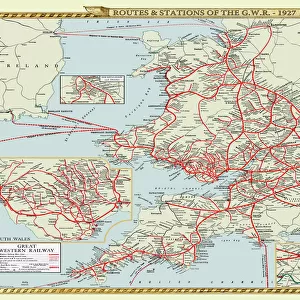
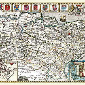
Jigsaw Puzzle : Old County Map of Cheshire 1648 by Johan Blaeu from the Atlas Novus


![]()
Jigsaw Puzzles From MapSeeker
Old County Map of Cheshire 1648 by Johan Blaeu from the Atlas Novus
This detailed and most attractive reproduction map of Cheshire has been carefully art worked from a scan of an antique original. The famous firm of Dutch cartographers and publishers was established in the late 16th century by Willem Janszoon Blaeu in Amsterdam. Blaeu was a maker of globes and scientific instruments and purchased some of his early map plates from Jodocus Hondius. From this small beginning was to emerge one of the largest and most prolific map publishing houses of the seventeenth century
Welcome to the Mapseeker Image library and enter an historic gateway to one of the largest on-line collections of Historic Maps, Nostalgic Views, Vista's and Panorama's from a World gone by.
Media ID 20347842
Blaeu Blaeu Family Blaue Map County Map County Map Of England English County Map Historic Map Johan Blaeu Johan Blaeu Map Old Blaue Map Old County Map Old English County Map Cheshire
Jigsaw Puzzle (1014 Pieces)
Discover the rich history of Cheshire with our Old County Map of Cheshire 1648 by Johan Blaeu from the Atlas Novus. This exquisite jigsaw puzzle, part of the Media Storehouse collection, is meticulously crafted from a high-resolution scan of an original antique map. The intricate details of the map, showcasing the counties, towns, and waterways of Cheshire during this historic period, come alive as you piece together this captivating puzzle. Immerse yourself in the past and enjoy the satisfaction of completing this beautiful and authentic representation of a bygone era.
Made in the USA, 1014-piece puzzles measure 20" x 30" (50.8 x 76.2 cm). Every puzzle is meticulously printed on glossy photo paper, which has a strong 1.33 mm thickness. Delivered in a black storage cardboard box, these puzzles are both stylish and practical. (Note: puzzles contain small parts and are not suitable for children under 3 years of age.)
Jigsaw Puzzles are an ideal gift for any occasion
Estimated Product Size is 76cm x 50.8cm (29.9" x 20")
These are individually made so all sizes are approximate
Artwork printed orientated as per the preview above, with landscape (horizontal) orientation to match the source image.
FEATURES IN THESE COLLECTIONS
> Arts
> Artists
> B
> Willem Blaeu
> Arts
> Artists
> H
> Jodocus Hondius
> Arts
> Photorealistic artworks
> Detailed art pieces
> Masterful detailing in art
> Europe
> United Kingdom
> England
> Cheshire
> Related Images
> Europe
> United Kingdom
> England
> Maps
> Maps and Charts
> Early Maps
> Maps and Charts
> Willem Janszoon Blaeu
> MapSeeker
> Maps from the British Isles
> England and Counties PORTFOLIO
EDITORS COMMENTS
This exquisite print showcases the "Old County Map of Cheshire 1648" by Johan Blaeu, a renowned Dutch cartographer and publisher. Carefully crafted from an antique original, this reproduction map captures the intricate details and allure of its historical counterpart. The Blaeu family's legacy began in the late 16th century when Willem Janszoon Blaeu established their firm in Amsterdam. Initially specializing in globes and scientific instruments, they soon expanded into map publishing. Acquiring some of their early map plates from Jodocus Hondius, the company flourished to become one of the largest and most prolific map publishing houses during the seventeenth century. This particular map focuses on Cheshire, an English county rich with history and charm. Its meticulous artistry transports us back to a time when maps were not only navigational tools but also works of art. With its ornate borders and precise geographical markings, it offers a captivating glimpse into Cheshire's past. Whether you are a history enthusiast or simply appreciate fine craftsmanship, this historic Cheshire map is sure to captivate your imagination. Displaying it proudly will not only add character to any space but also serve as a reminder of our enduring fascination with cartography throughout centuries.
MADE IN THE USA
Safe Shipping with 30 Day Money Back Guarantee
FREE PERSONALISATION*
We are proud to offer a range of customisation features including Personalised Captions, Color Filters and Picture Zoom Tools
SECURE PAYMENTS
We happily accept a wide range of payment options so you can pay for the things you need in the way that is most convenient for you
* Options may vary by product and licensing agreement. Zoomed Pictures can be adjusted in the Basket.