Jigsaw Puzzle > Arts > Photorealistic artworks > Detailed art pieces > Masterful detailing in art
Jigsaw Puzzle : Old Map of Exeter 1805 by Cole and Roper


![]()
Jigsaw Puzzles From MapSeeker
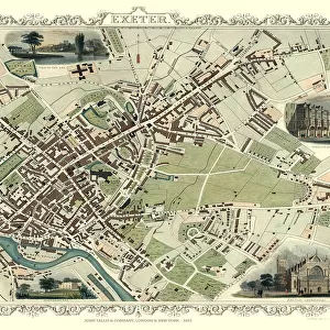
Old Map of Exeter 1805 by Cole and Roper
An attractive and detailed early 19th century reproduction town plan of Exeter 1805. First published by Cole and Roper as a finely engraved series of county maps and town plans which were initially issued in parts and then together as The British Atlas in 1810
Welcome to the Mapseeker Image library and enter an historic gateway to one of the largest on-line collections of Historic Maps, Nostalgic Views, Vista's and Panorama's from a World gone by.
Media ID 20348092
© Mapseeker Publishing Ltd
Cole And Roper Historic Map Old Town Plan Exeter
Jigsaw Puzzle (520 Pieces)
Discover the rich history of Exeter with our Old Map of Exeter 1805 by Cole and Roper from Media Storehouse. This beautifully detailed jigsaw puzzle showcases an early 19th century reproduction town plan of Exeter, first published by Cole and Roper as a finely engraved series of county maps. Bring the past to life as you piece together this captivating puzzle, featuring intricate architectural and topographical details. A perfect addition to any home or office, this puzzle is not only a fun and engaging activity, but also a beautiful work of art to display once completed.
Made in the USA, 520-piece puzzles measure 16" x 20" (40.6 x 50.8 cm). Every puzzle is meticulously printed on glossy photo paper, which has a strong 1.33 mm thickness. Delivered in a black storage cardboard box, these puzzles are both stylish and practical. (Note: puzzles contain small parts and are not suitable for children under 3 years of age.)
Jigsaw Puzzles are an ideal gift for any occasion
Estimated Product Size is 40.5cm x 50.8cm (15.9" x 20")
These are individually made so all sizes are approximate
Artwork printed orientated as per the preview above, with landscape (horizontal) or portrait (vertical) orientation to match the source image.
FEATURES IN THESE COLLECTIONS
> Arts
> Photorealistic artworks
> Detailed art pieces
> Masterful detailing in art
> Maps and Charts
> Early Maps
EDITORS COMMENTS
This print showcases an exquisite reproduction of the "Old Map of Exeter 1805" by Cole and Roper. Transporting us back to the early 19th century, this detailed town plan provides a fascinating glimpse into the historic city of Exeter. Originally published as part of a meticulously engraved series of county maps and town plans, this particular map was first released in sections before being compiled into The British Atlas in 1810. Its intricate design and attractive aesthetic make it a true collector's item for history enthusiasts. The map itself offers a wealth of information about Exeter during that era. From its winding streets to notable landmarks, every corner is meticulously depicted with precision and care. This visual representation allows us to explore the city's layout as it existed over two centuries ago. As we delve into this old town plan, we uncover the rich heritage that defines Exeter. It serves as a reminder of how cities evolve over time while retaining their unique character. Whether you are an avid historian or simply appreciate beautiful cartography, this stunning print will undoubtedly captivate your imagination. With its timeless charm and historical significance, the "Old Map of Exeter 1805" by Cole and Roper is not just a piece of art but also an invaluable window into our past.
MADE IN THE USA
Safe Shipping with 30 Day Money Back Guarantee
FREE PERSONALISATION*
We are proud to offer a range of customisation features including Personalised Captions, Color Filters and Picture Zoom Tools
SECURE PAYMENTS
We happily accept a wide range of payment options so you can pay for the things you need in the way that is most convenient for you
* Options may vary by product and licensing agreement. Zoomed Pictures can be adjusted in the Basket.