Jigsaw Puzzle > Animals > Mammals > Muridae > Fortior
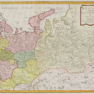
Jigsaw Puzzle : Map of the Russian Empire Divided Into Forty-One Governments, 1796


![]()
Jigsaw Puzzles From Heritage Images
Map of the Russian Empire Divided Into Forty-One Governments, 1796
Map of the Russian Empire Divided Into Forty-One Governments, 1796. Private Collection
Heritage Images features heritage image collections
Media ID 24030074
© Fine Art Images/Heritage Images
Cartography Government Governorate Governorates Gubernia Guberniia Guberniya Gubernya Russian Empire
Jigsaw Puzzle (1014 Pieces)
Discover the rich history of the Russian Empire with our captivating jigsaw puzzle from Media Storehouse. This intricately detailed puzzle showcases a historical map of the Russian Empire, divided into forty-one governments, as it appeared in 1796. Featuring an authentic reproduction of the map from Fine Art Images/Heritage Images, this puzzle is a must-have for history enthusiasts and puzzle lovers alike. Immerse yourself in the past as you piece together this stunning representation of a bygone era. Engaging, educational, and visually stunning, this puzzle is sure to provide hours of enjoyment and satisfaction.
Made in the USA, 1014-piece puzzles measure 20" x 30" (50.8 x 76.2 cm). Every puzzle is meticulously printed on glossy photo paper, which has a strong 1.33 mm thickness. Delivered in a black storage cardboard box, these puzzles are both stylish and practical. (Note: puzzles contain small parts and are not suitable for children under 3 years of age.)
Jigsaw Puzzles are an ideal gift for any occasion
Estimated Product Size is 76cm x 50.8cm (29.9" x 20")
These are individually made so all sizes are approximate
Artwork printed orientated as per the preview above, with landscape (horizontal) orientation to match the source image.
FEATURES IN THESE COLLECTIONS
> Animals
> Mammals
> Muridae
> Fortior
> Maps and Charts
> Related Images
EDITORS COMMENTS
This print showcases a historical gem, the "Map of the Russian Empire Divided Into Forty-One Governments, 1796". Created by Alexander (1757-1823), this piece of cartography is a testament to his skill and artistry. The map, now part of a private collection, offers an intriguing glimpse into the vastness and complexity of the Russian Empire during that era. Divided into forty-one governments or governorates, this meticulously detailed lithograph provides valuable insights into the administrative divisions and geographic boundaries of Russia at the time. Each guberniya is intricately depicted with precision and clarity, allowing viewers to immerse themselves in its rich history. The graphic arts employed in this map are truly remarkable. From fine lines delineating borders to carefully chosen colors representing different regions, every element has been thoughtfully crafted. This masterpiece not only serves as a navigational tool but also as an exquisite work of art. As we explore this image further, it becomes evident that Wilbrecht Wildbrecht's expertise in capturing such historical treasures shines through once again. Fine Art Images/Heritage Images have expertly preserved and reproduced this print for all enthusiasts to appreciate. Whether you are fascinated by history or simply admire beautiful works of art, this print transports you back in time to witness the grandeur and magnitude of the Russian Empire in 1796.
MADE IN THE USA
Safe Shipping with 30 Day Money Back Guarantee
FREE PERSONALISATION*
We are proud to offer a range of customisation features including Personalised Captions, Color Filters and Picture Zoom Tools
SECURE PAYMENTS
We happily accept a wide range of payment options so you can pay for the things you need in the way that is most convenient for you
* Options may vary by product and licensing agreement. Zoomed Pictures can be adjusted in the Basket.