Jigsaw Puzzle > Arts > Landscape paintings > Waterfall and river artworks > River artworks
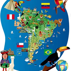
Jigsaw Puzzle : SOUTH AMERICA: MAP, c1890. Published in the United States


![]()
Jigsaw Puzzles from Granger
SOUTH AMERICA: MAP, c1890. Published in the United States
Granger holds millions of images spanning more than 25,000 years of world history, from before the Stone Age to the dawn of the Space Age
Media ID 6617411
Jigsaw Puzzle (520 Pieces)
Discover the wonders of South America with our captivating jigsaw puzzle from Media Storehouse, featuring a vintage map of the region published in the United States in 1890. This intricately detailed puzzle, sourced from The Granger Collection at Granger Art on Demand, invites you on a journey back in time. Explore the rich history and diverse landscapes of South America as you piece together this beautiful and educational puzzle. Ideal for puzzle enthusiasts, history buffs, and anyone seeking a challenging and rewarding pastime.
Made in the USA, 520-piece puzzles measure 16" x 20" (40.6 x 50.8 cm). Every puzzle is meticulously printed on glossy photo paper, which has a strong 1.33 mm thickness. Delivered in a black storage cardboard box, these puzzles are both stylish and practical. (Note: puzzles contain small parts and are not suitable for children under 3 years of age.)
Jigsaw Puzzles are an ideal gift for any occasion
Estimated Product Size is 40.5cm x 50.8cm (15.9" x 20")
These are individually made so all sizes are approximate
Artwork printed orientated as per the preview above, with landscape (horizontal) or portrait (vertical) orientation to match the source image.
FEATURES IN THESE COLLECTIONS
> Granger Art on Demand
> Maps
> Arts
> Landscape paintings
> Waterfall and river artworks
> River artworks
> Maps and Charts
> Related Images
> South America
> Related Images
EDITORS COMMENTS
This print showcases a vintage map of South America, dating back to the late 19th century. Published in the United States around 1890, this meticulously crafted piece offers a glimpse into the geographical landscape of this diverse and enchanting continent. The intricate details on this map highlight the various countries, cities, rivers, and mountain ranges that define South America's rich topography. As we delve into this historical artifact, we are transported to an era where exploration and discovery were at their peak. This map serves as a window into the past, shedding light on how our understanding of South America has evolved over time. It reminds us of the countless expeditions undertaken by intrepid explorers who ventured deep into uncharted territories in search of new knowledge. The Granger Collection has masterfully preserved this timeless treasure from their vast archives. Their dedication to preserving history through art is evident in every brushstroke and line on this print. Whether you're an avid traveler or simply fascinated by cartography and geography, this exquisite piece will undoubtedly captivate your imagination. Hang it proudly in your home or office space as a testament to human curiosity and our never-ending quest for knowledge about our world. Let it inspire you to embark on your own adventures or spark conversations about the wonders that lie within South America's borders.
MADE IN THE USA
Safe Shipping with 30 Day Money Back Guarantee
FREE PERSONALISATION*
We are proud to offer a range of customisation features including Personalised Captions, Color Filters and Picture Zoom Tools
SECURE PAYMENTS
We happily accept a wide range of payment options so you can pay for the things you need in the way that is most convenient for you
* Options may vary by product and licensing agreement. Zoomed Pictures can be adjusted in the Cart.