Jigsaw Puzzle > Europe > Poland > Maps
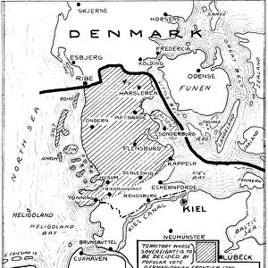
Jigsaw Puzzle : WORLD WAR I: MAP, 1919. Map showing sections of Eastern Germany that were taken away


![]()
Jigsaw Puzzles from Granger
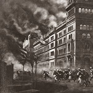
WORLD WAR I: MAP, 1919. Map showing sections of Eastern Germany that were taken away
WORLD WAR I: MAP, 1919.
Map showing sections of Eastern Germany that were taken away, internationalized or subject to plebiscite under the terms of the Treaty of Versailles. Map, 1919
Granger holds millions of images spanning more than 25,000 years of world history, from before the Stone Age to the dawn of the Space Age
Media ID 12406598
1919 Boundary Eastern Germany Poland Treaty Of Versailles World War I Divide
Jigsaw Puzzle (520 Pieces)
Delve into history with our captivating WORLD WAR I: MAP, 1919 jigsaw puzzle from Media Storehouse, brought to you by Granger Art on Demand. This intricately detailed puzzle depicts a significant moment in world history, showcasing the territorial changes in Eastern Germany following the Treaty of Versailles. Assemble this puzzle to not only challenge your mind but also gain a deeper understanding of the political landscape during the aftermath of World War I. Ideal for history enthusiasts and puzzle lovers alike, this educational and engaging puzzle is a must-have addition to your collection.
Made in the USA, 520-piece puzzles measure 16" x 20" (40.6 x 50.8 cm). Every puzzle is meticulously printed on glossy photo paper, which has a strong 1.33 mm thickness. Delivered in a black storage cardboard box, these puzzles are both stylish and practical. (Note: puzzles contain small parts and are not suitable for children under 3 years of age.)
Jigsaw Puzzles are an ideal gift for any occasion
Estimated Product Size is 40.5cm x 50.8cm (15.9" x 20")
These are individually made so all sizes are approximate
Artwork printed orientated as per the preview above, with landscape (horizontal) or portrait (vertical) orientation to match the source image.
FEATURES IN THESE COLLECTIONS
> Granger Art on Demand
> 20th Century Wars
> Europe
> Poland
> Related Images
> Historic
> World War I and II
> World War I
> Maps and Charts
> Related Images
> Maps and Charts
> World
EDITORS COMMENTS
This print from Granger Art on Demand showcases a significant historical artifact - a map dating back to 1919, depicting the aftermath of World War I. The map specifically highlights sections of Eastern Germany that were affected by the terms outlined in the Treaty of Versailles. The image serves as a visual representation of the profound impact this treaty had on German territory. It vividly illustrates how certain regions were either taken away, internationalized, or subjected to plebiscite under the provisions set forth in this pivotal agreement. By examining this map closely, one can gain valuable insights into the complex geopolitical landscape that emerged after World War I. It reveals not only the territorial divisions but also sheds light on how boundaries were redrawn and nations reconfigured during this transformative period in history. Moreover, this photograph print is an invaluable resource for historians and enthusiasts alike who seek to understand and analyze the consequences of World War I. Its depiction provides a tangible connection to an era marked by political negotiations and global realignments. Overall, this striking image offers viewers an opportunity to delve into history's pages and witness firsthand how treaties such as Versailles shaped nations' destinies while leaving indelible imprints on their borders.
MADE IN THE USA
Safe Shipping with 30 Day Money Back Guarantee
FREE PERSONALISATION*
We are proud to offer a range of customisation features including Personalised Captions, Color Filters and Picture Zoom Tools
SECURE PAYMENTS
We happily accept a wide range of payment options so you can pay for the things you need in the way that is most convenient for you
* Options may vary by product and licensing agreement. Zoomed Pictures can be adjusted in the Cart.