Jigsaw Puzzle > Arts > Artists > M > Mexican School Mexican School
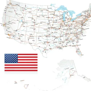
Jigsaw Puzzle : Map of Pacific States USA 1877


![]()
Jigsaw Puzzles from Fine Art Storehouse
Map of Pacific States USA 1877
Warrens Common School Geography 1877
Unleash your creativity and transform your space into a visual masterpiece!
THEPALMER
Media ID 14824575
© This content is subject to copyright
Arizona California Colorado Montana New Mexico Oregon Pacific Washington Wyoming
Jigsaw Puzzle (520 Pieces)
Discover the rich history of the Pacific States USA in 1877 with our captivating jigsaw puzzle from Media Storehouse. Featuring an intricately detailed map of the region, this puzzle brings to life the geography as it was depicted in Warrens Common School's 1877 publication. Produced in collaboration with Fine Art Storehouse and artist THEPALMER, this jigsaw puzzle offers a fun and educational experience for all ages. Engage in a journey through history, sharpen your problem-solving skills, and create a beautiful display piece with this unique puzzle. Perfect for history enthusiasts, geography buffs, or anyone looking for a challenging puzzle experience.
Made in the USA, 520-piece puzzles measure 16" x 20" (40.6 x 50.8 cm). Every puzzle is meticulously printed on glossy photo paper, which has a strong 1.33 mm thickness. Delivered in a black storage cardboard box, these puzzles are both stylish and practical. (Note: puzzles contain small parts and are not suitable for children under 3 years of age.)
Jigsaw Puzzles are an ideal gift for any occasion
Estimated Product Size is 40.5cm x 50.8cm (15.9" x 20")
These are individually made so all sizes are approximate
Artwork printed orientated as per the preview above, with landscape (horizontal) or portrait (vertical) orientation to match the source image.
FEATURES IN THESE COLLECTIONS
> Fine Art Storehouse
> Map
> Historical Maps
> Fine Art Storehouse
> Map
> USA Maps
> Animals
> Mammals
> Cricetidae
> California Mouse
> Arts
> Artists
> M
> Mexican School Mexican School
> Maps and Charts
> Related Images
> North America
> Mexico
> Related Images
> North America
> United States of America
> Arizona
> Related Images
> North America
> United States of America
> California
> Related Images
> North America
> United States of America
> Colorado
> Related Images
> North America
> United States of America
> Maps
> North America
> United States of America
> Montana
> Related Images
> North America
> United States of America
> New Mexico
> Related Images
EDITORS COMMENTS
In this print titled "Map of Pacific States USA 1877" we are transported back in time to the late 19th century, where cartography was both an art form and a means of education. This particular map, sourced from Warrens Common School Geography in 1877, offers us a glimpse into the vast expanse of the Pacific States region. The intricate details on this vintage map allow us to explore the territories that make up present-day Arizona, California, Colorado, Montana, New Mexico, Oregon, Washington state and Wyoming. It is fascinating to see how these states were depicted over a century ago when their landscapes were still largely untamed and unexplored. The craftsmanship evident in this print by THEPALMER showcases not only historical accuracy but also artistic flair. The delicate lines and vibrant colors bring life to each state's boundaries while highlighting major cities and geographical features. As we study this piece closely, it becomes apparent that maps served as more than just navigational tools; they were windows into the world for students eager to learn about their surroundings. This photograph captures not only a moment frozen in time but also represents an important milestone in American history – an era marked by westward expansion and exploration. Whether you are a history enthusiast or simply appreciate fine art prints like this one from Fine Art Storehouse, "Map of Pacific States USA 1877" serves as a reminder of our ever-evolving understanding of geography and its impact on society throughout the ages.
MADE IN THE USA
Safe Shipping with 30 Day Money Back Guarantee
FREE PERSONALISATION*
We are proud to offer a range of customisation features including Personalised Captions, Color Filters and Picture Zoom Tools
SECURE PAYMENTS
We happily accept a wide range of payment options so you can pay for the things you need in the way that is most convenient for you
* Options may vary by product and licensing agreement. Zoomed Pictures can be adjusted in the Cart.