Jigsaw Puzzle > Arts > Photorealistic artworks > Detailed art pieces > Masterful detailing in art
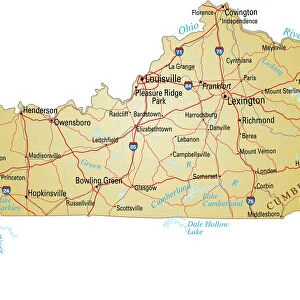
Jigsaw Puzzle : Kentucky Vector Map


![]()
Jigsaw Puzzles From Fine Art Storehouse
Kentucky Vector Map
Highly detailed vector map of Kentucky, United States. Source data courtesy of NGDC (database: World Data Bank II), NASA (reference images: Blue Marble) and National Atlas (database: county boundaries). The source data is in the public domain. Data updated and improved. File was created on May 22, 2013. The colors in the.eps-file are ready for print (CMYK). Included files: EPS (v8) and Hi-Res JPG (5600aua5600 px)
Unleash your creativity and transform your space into a visual masterpiece!
Media ID 14833471
Jigsaw Puzzle (520 Pieces)
Discover the intricacies of Kentucky with our latest addition to the Media Storehouse Jigsaw Puzzles collection. This highly detailed puzzle features a vector map of the Bluegrass State, meticulously crafted from data sourced from NGDC, NASA, and the National Atlas. Explore the winding waterways, rolling hills, and vibrant cities of Kentucky with every piece. A captivating challenge for puzzle enthusiasts and geography buffs alike.
Made in the USA, 520-piece puzzles measure 16" x 20" (40.6 x 50.8 cm). Every puzzle is meticulously printed on glossy photo paper, which has a strong 1.33 mm thickness. Delivered in a black storage cardboard box, these puzzles are both stylish and practical. (Note: puzzles contain small parts and are not suitable for children under 3 years of age.)
Jigsaw Puzzles are an ideal gift for any occasion
Estimated Product Size is 40.5cm x 50.8cm (15.9" x 20")
These are individually made so all sizes are approximate
Artwork printed orientated as per the preview above, with landscape (horizontal) or portrait (vertical) orientation to match the source image.
FEATURES IN THESE COLLECTIONS
> Fine Art Storehouse
> Map
> Map Illustrations
> Arts
> Photorealistic artworks
> Detailed art pieces
> Masterful detailing in art
> Maps and Charts
> Related Images
> Maps and Charts
> World
> Science
> Space Exploration
> Related Images
EDITORS COMMENTS
This highly detailed vector map of Kentucky showcases the beauty and intricacies of this state in the United States. Created using source data from NGDC, NASA, and National Atlas, this print is a testament to the collaborative efforts of these esteemed organizations. The rich colors in the . eps-file are specifically designed for print (CMYK), ensuring that every detail is vividly captured. Whether you choose to display it in your home or office, this map will undoubtedly serve as an eye-catching centerpiece. With updated and improved data, this print offers an accurate representation of Kentucky's geography and county boundaries. The meticulous craftsmanship behind its creation guarantees precision and authenticity. As a bonus, included with your purchase are EPS (v8) and Hi-Res JPG files, allowing you to explore different ways to enjoy this stunning artwork. From digital displays to high-quality prints on various mediums, the possibilities are endless.
MADE IN THE USA
Safe Shipping with 30 Day Money Back Guarantee
FREE PERSONALISATION*
We are proud to offer a range of customisation features including Personalised Captions, Color Filters and Picture Zoom Tools
SECURE PAYMENTS
We happily accept a wide range of payment options so you can pay for the things you need in the way that is most convenient for you
* Options may vary by product and licensing agreement. Zoomed Pictures can be adjusted in the Basket.