Jigsaw Puzzle > Europe > Germany > Maps
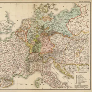
Jigsaw Puzzle : Saxon duchies, principalities Schwarzburg and Reuss (Germany), lithograph, 1897
, lithograph, 1897")
, lithograph, 1897")


![]()
Jigsaw Puzzles From Fine Art Storehouse
Saxon duchies, principalities Schwarzburg and Reuss (Germany), lithograph, 1897
Topographic map of Saxon duchies, principalities Schwarzburg and Reuss (Germany). Lithograph, published in 1897
Unleash your creativity and transform your space into a visual masterpiece!
ZU_09
Media ID 18356553
Jigsaw Puzzle (520 Pieces)
Discover the rich history of Europe with our exquisite jigsaw puzzle from Media Storehouse. Featuring the intricately detailed topographic map of Saxon duchies, principalities Schwarzburg and Reuss, published in 1897. This captivating puzzle, based on the lithograph by ZU_09 from Fine Art Storehouse, transports you back in time to the historical Saxon regions of Germany. Assemble this challenging yet rewarding puzzle to bring the intricacies of the past into your home and ignite your sense of discovery. Perfect for history enthusiasts, collectors, and families looking for a stimulating activity.
Made in the USA, 520-piece puzzles measure 16" x 20" (40.6 x 50.8 cm). Every puzzle is meticulously printed on glossy photo paper, which has a strong 1.33 mm thickness. Delivered in a black storage cardboard box, these puzzles are both stylish and practical. (Note: puzzles contain small parts and are not suitable for children under 3 years of age.)
Jigsaw Puzzles are an ideal gift for any occasion
Estimated Product Size is 50.8cm x 40.5cm (20" x 15.9")
These are individually made so all sizes are approximate
Artwork printed orientated as per the preview above, with landscape (horizontal) or portrait (vertical) orientation to match the source image.
FEATURES IN THESE COLLECTIONS
> Fine Art Storehouse
> Map
> Historical Maps
> Europe
> Germany
> Related Images
> Maps and Charts
> Related Images
EDITORS COMMENTS
This lithograph from 1897 showcases the intricate topographic map of the Saxon duchies, principalities Schwarzburg and Reuss in Germany. The print, skillfully created by ZU_09, offers a glimpse into the historical geography of this region during that era. The lithograph is a testament to the meticulous craftsmanship employed by cartographers of yesteryears. Every contour line and minute detail has been painstakingly etched onto the paper, resulting in an exquisite representation of these German territories. The precision with which each boundary is delineated reflects not only technical expertise but also a deep understanding of geographical accuracy. As one gazes upon this artwork, it transports us back to a time when maps were meticulously hand-drawn and served as crucial navigational tools for explorers and travelers alike. It evokes nostalgia for an era when technology had yet to dominate our lives. Beyond its aesthetic appeal, this lithograph serves as a valuable historical artifact. It provides insight into the political landscape of late 19th-century Germany, highlighting the existence of various duchies and principalities within Saxony. Such prints are invaluable resources for researchers seeking to understand the geopolitical dynamics that shaped Europe during that period. In essence, this lithograph captures both artistic beauty and historical significance within its delicate lines and intricate details – truly deserving its place among fine art collections worldwide.
MADE IN THE USA
Safe Shipping with 30 Day Money Back Guarantee
FREE PERSONALISATION*
We are proud to offer a range of customisation features including Personalised Captions, Color Filters and Picture Zoom Tools
SECURE PAYMENTS
We happily accept a wide range of payment options so you can pay for the things you need in the way that is most convenient for you
* Options may vary by product and licensing agreement. Zoomed Pictures can be adjusted in the Basket.