Jigsaw Puzzle > Europe > Bosnia and Herzegovina > Maps
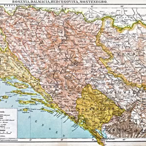
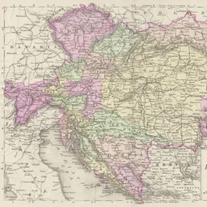
Jigsaw Puzzle : Old map of Serbia and Bosnia, steel engraving, published 1857


![]()
Jigsaw Puzzles From Fine Art Storehouse
Old map of Serbia and Bosnia, steel engraving, published 1857
Old map of Serbia and Bosnia. Steel engraving with hand coloured borderlines, published in 1857
Unleash your creativity and transform your space into a visual masterpiece!
ZU_09
Media ID 35842846
Jigsaw Puzzle (520 Pieces)
Step back in time with our antique Old Map of Serbia and Bosnia jigsaw puzzle from Media Storehouse. This intricately detailed puzzle features a steel engraving of a historical map, published in 1857 by ZU_09 from the Fine Art Storehouse. The map showcases the regions of Serbia and Bosnia with hand-coloured borderlines, providing an educational and engaging puzzle experience. Perfect for history enthusiasts, puzzle collectors, or anyone looking to add a touch of the past to their home, this vintage puzzle is sure to provide hours of enjoyable challenge and satisfaction.
Made in the USA, 520-piece puzzles measure 16" x 20" (40.6 x 50.8 cm). Every puzzle is meticulously printed on glossy photo paper, which has a strong 1.33 mm thickness. Delivered in a black storage cardboard box, these puzzles are both stylish and practical. (Note: puzzles contain small parts and are not suitable for children under 3 years of age.)
Jigsaw Puzzles are an ideal gift for any occasion
Estimated Product Size is 50.8cm x 40.5cm (20" x 15.9")
These are individually made so all sizes are approximate
Artwork printed orientated as per the preview above, with landscape (horizontal) or portrait (vertical) orientation to match the source image.
FEATURES IN THESE COLLECTIONS
> Fine Art Storehouse
> Map
> Historical Maps
> Europe
> Bosnia and Herzegovina
> Maps
> Europe
> Serbia
> Related Images
> Maps and Charts
> Bosnia and Herzegovina
EDITORS COMMENTS
This exquisite steel engraving, titled 'Old Map of Serbia and Bosnia,' dates back to 1857. The intricate details of this antique map are a testament to the cartographic skills of the time. The map covers the regions of Serbia and Bosnia, two historically rich and culturally diverse areas in Southeastern Europe. The borders of various principalities and territories are delineated with hand-coloured lines, adding an artistic touch to the otherwise monochrome engraving. The map offers a glimpse into the political landscape of the 19th century, with the Austrian Empire, the Ottoman Empire, and various smaller principalities and states marked out in their respective territories. The Danube River, Sava River, and Drina River are depicted with remarkable accuracy, providing a sense of the geographical features of the region. The Old Map of Serbia and Bosnia is not only a historical document, but also a work of art. The intricate engraving technique, combined with the vibrant hand-coloured borders, creates a visual feast for the eyes. The map serves as a reminder of the rich history and complex political landscape of the Balkans during the 19th century. It is a must-have for collectors of historical maps, cartography enthusiasts, and anyone with an interest in European history and culture.
MADE IN THE USA
Safe Shipping with 30 Day Money Back Guarantee
FREE PERSONALISATION*
We are proud to offer a range of customisation features including Personalised Captions, Color Filters and Picture Zoom Tools
SECURE PAYMENTS
We happily accept a wide range of payment options so you can pay for the things you need in the way that is most convenient for you
* Options may vary by product and licensing agreement. Zoomed Pictures can be adjusted in the Basket.