Jigsaw Puzzle > Arts > Street art graffiti > Digital art > Digital paintings
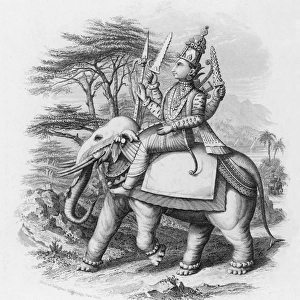
Jigsaw Puzzle : Old map of India, showing the British possessions in 1780-1800


![]()
Jigsaw Puzzles From Fine Art Storehouse
Old map of India, showing the British possessions in 1780-1800
Antique Illustration, Copyright has expired on this artwork. From my own archives, digitally restored
Unleash your creativity and transform your space into a visual masterpiece!
mikroman6
Media ID 24796639
© 2014-2022 Tomasz Skoczen
Jigsaw Puzzle (1014 Pieces)
Discover the rich history of India with our captivating Old Map of India jigsaw puzzle from Media Storehouse. This intricately detailed puzzle, featuring an antique illustration by mikroman6 from the Fine Art Storehouse, showcases the British possessions in India during the late 18th and early 19th centuries. Perfect for history buffs, puzzle enthusiasts, or anyone who appreciates the beauty of antique maps, this puzzle offers a challenging and rewarding experience. Digitally restored for optimal quality, each piece fits seamlessly into the larger puzzle, bringing the historical map to life piece by piece. Immerse yourself in a journey through time as you piece together this stunning representation of India's past.
Made in the USA, 1014-piece puzzles measure 20" x 30" (50.8 x 76.2 cm). Every puzzle is meticulously printed on glossy photo paper, which has a strong 1.33 mm thickness. Delivered in a black storage cardboard box, these puzzles are both stylish and practical. (Note: puzzles contain small parts and are not suitable for children under 3 years of age.)
Jigsaw Puzzles are an ideal gift for any occasion
Estimated Product Size is 50.8cm x 76cm (20" x 29.9")
These are individually made so all sizes are approximate
Artwork printed orientated as per the preview above, with portrait (vertical) orientation to match the source image.
FEATURES IN THESE COLLECTIONS
> Arts
> Street art graffiti
> Digital art
> Digital paintings
> Asia
> India
> Related Images
> Maps and Charts
> India
> Maps and Charts
> Related Images
EDITORS COMMENTS
This print takes us back in time to the era of British colonial rule in India. The old map, dating between 1780 and 1800, showcases the vast extent of British possessions during that period. With its intricate details and faded hues, this antique illustration offers a glimpse into a significant chapter of history. The copyright on this artwork has long expired, allowing us to appreciate it freely without any legal restrictions. Thanks to meticulous digital restoration from the archives of mikroman6, we can now admire this historical gem with enhanced clarity and precision. As we delve into the map's intricacies, we witness how the British Empire once held sway over various regions across India. From bustling cities to remote villages, their influence is evident through marked territories and strategically positioned landmarks. This print serves as a reminder of an epoch when borders were redrawn and cultures intertwined under foreign dominion. It invites contemplation on the impact of colonization on indigenous populations while also acknowledging the rich tapestry of heritage that emerged from these interactions. Whether you are an avid historian or simply fascinated by cartography, this print transports you back in time like few others can. It allows us to explore not only geographical boundaries but also cultural exchanges that have shaped our world today.
MADE IN THE USA
Safe Shipping with 30 Day Money Back Guarantee
FREE PERSONALISATION*
We are proud to offer a range of customisation features including Personalised Captions, Color Filters and Picture Zoom Tools
SECURE PAYMENTS
We happily accept a wide range of payment options so you can pay for the things you need in the way that is most convenient for you
* Options may vary by product and licensing agreement. Zoomed Pictures can be adjusted in the Basket.