Jigsaw Puzzle > Europe > United Kingdom > England > Related Images
Jigsaw Puzzle : New England states map 1867


![]()
Jigsaw Puzzles From Fine Art Storehouse
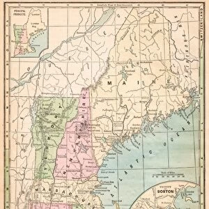
New England states map 1867
Guyots Geographical Series The Earth and its inhabitants 1867 New York
Unleash your creativity and transform your space into a visual masterpiece!
THEPALMER
Media ID 14756936
© This content is subject to copyright
Jigsaw Puzzle (520 Pieces)
Discover the charm of the past with our New England States Map jigsaw puzzle from ThePalmer's Guyots Geographical Series, published in 1867. This intriguing puzzle, featuring the New England states as they appeared over a century ago, offers a captivating journey back in time. The vibrant colors and intricate details of this fine art puzzle bring the historical map to life, making it an engaging and educational activity for puzzle enthusiasts of all ages. Immerse yourself in the rich history of the New England region and enjoy the satisfaction of piecing together this beautiful puzzle.
Made in the USA, 520-piece puzzles measure 16" x 20" (40.6 x 50.8 cm). Every puzzle is meticulously printed on glossy photo paper, which has a strong 1.33 mm thickness. Delivered in a black storage cardboard box, these puzzles are both stylish and practical. (Note: puzzles contain small parts and are not suitable for children under 3 years of age.)
Jigsaw Puzzles are an ideal gift for any occasion
Estimated Product Size is 40.5cm x 50.8cm (15.9" x 20")
These are individually made so all sizes are approximate
Artwork printed orientated as per the preview above, with landscape (horizontal) or portrait (vertical) orientation to match the source image.
FEATURES IN THESE COLLECTIONS
> Fine Art Storehouse
> Map
> Historical Maps
> Europe
> United Kingdom
> England
> Related Images
> North America
> United States of America
> New York
> Related Images
EDITORS COMMENTS
In this print titled "New England states map 1867" we are transported back in time to the year 1867, when cartography was a meticulous art form. The image showcases an exquisite map from Guyot's Geographical Series, part of the renowned publication "The Earth and its Inhabitants". This particular edition hails from New York City. The map itself is a testament to both scientific precision and artistic craftsmanship. Every contour, river, and town is intricately detailed with delicate lines and vibrant colors that bring life to the paper. As we examine it closely, we can almost feel the dedication poured into its creation. This vintage piece offers us a glimpse into the past, allowing us to explore New England as it stood over 150 years ago. It evokes a sense of nostalgia for simpler times when maps were physical objects rather than digital pixels on screens. "The Palmer" has skillfully captured this historical gem through their lens, preserving its beauty for generations to come. This photograph print serves as a reminder of our collective history and invites us to appreciate the artistry behind these invaluable relics of knowledge. Whether displayed in an educational institution or cherished within a private collection, this remarkable artwork transports viewers on an enchanting journey through time while celebrating both science and artistry at their finest.
MADE IN THE USA
Safe Shipping with 30 Day Money Back Guarantee
FREE PERSONALISATION*
We are proud to offer a range of customisation features including Personalised Captions, Color Filters and Picture Zoom Tools
SECURE PAYMENTS
We happily accept a wide range of payment options so you can pay for the things you need in the way that is most convenient for you
* Options may vary by product and licensing agreement. Zoomed Pictures can be adjusted in the Basket.