Jigsaw Puzzle > Maps and Charts > World
Jigsaw Puzzle : Map of the World 1900


![]()
Jigsaw Puzzles From Fine Art Storehouse
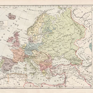
Map of the World 1900
Meyers hand-Atlas Leipzig und Wien Verlag des Bibliographischen Instituts 1900
Unleash your creativity and transform your space into a visual masterpiece!
THEPALMER
Media ID 18356609
Jigsaw Puzzle (520 Pieces)
Discover the rich history of cartography with our exquisite "Map of the World 1900" jigsaw puzzle from ThePalmer at Media Storehouse. This intriguing puzzle, inspired by the Fine Art Storehouse's reproduction of the original map published by Meyers Hand-Atlas Leipzig und Wien Verlag des Bibliographischen Instituts in 1900, offers a captivating journey through the geopolitical landscape of a bygone era. Assemble this puzzle to reveal a stunning representation of the world as it was known over a century ago. Perfect for history enthusiasts, puzzle aficionados, or anyone seeking an engaging and educational activity, this high-quality puzzle is sure to provide hours of enjoyment and a sense of accomplishment upon completion.
Made in the USA, 520-piece puzzles measure 16" x 20" (40.6 x 50.8 cm). Every puzzle is meticulously printed on glossy photo paper, which has a strong 1.33 mm thickness. Delivered in a black storage cardboard box, these puzzles are both stylish and practical. (Note: puzzles contain small parts and are not suitable for children under 3 years of age.)
Jigsaw Puzzles are an ideal gift for any occasion
Estimated Product Size is 50.8cm x 40.5cm (20" x 15.9")
These are individually made so all sizes are approximate
Artwork printed orientated as per the preview above, with landscape (horizontal) or portrait (vertical) orientation to match the source image.
FEATURES IN THESE COLLECTIONS
> Fine Art Storehouse
> Map
> Historical Maps
> Maps and Charts
> World
EDITORS COMMENTS
In this print titled "Map of the World 1900" we are transported back in time to an era when cartography was both a science and an art form. The image, sourced from Meyers hand-Atlas Leipzig und Wien Verlag des Bibliographischen Instituts in 1900, showcases the intricate details and craftsmanship that went into creating maps during this period. As our eyes wander across the map's surface, we are immediately struck by its sheer magnitude. Every continent, country, and ocean is meticulously depicted with precision and accuracy. It serves as a testament to human curiosity and exploration - a visual representation of how far we have come in understanding our world. The sepia-toned hues lend an air of nostalgia to the piece, evoking a sense of adventure reminiscent of explorers setting sail on uncharted waters. Each line etched onto the paper tells stories of expeditions undertaken by brave souls seeking knowledge beyond their own horizons. "The Map of the World 1900" transports us not only through space but also through time. It invites us to reflect on how much has changed since then while appreciating the beauty found within historical artifacts like this one. THEPALMER's expertly captured photograph allows us to bring home a piece of history – reminding us that even amidst technological advancements today, there is still immense value in preserving these tangible relics that connect us with our past.
MADE IN THE USA
Safe Shipping with 30 Day Money Back Guarantee
FREE PERSONALISATION*
We are proud to offer a range of customisation features including Personalised Captions, Color Filters and Picture Zoom Tools
SECURE PAYMENTS
We happily accept a wide range of payment options so you can pay for the things you need in the way that is most convenient for you
* Options may vary by product and licensing agreement. Zoomed Pictures can be adjusted in the Basket.