Jigsaw Puzzle > South America > Brazil > Maps
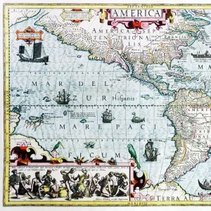
Jigsaw Puzzle : Map of South Brazil 1900


![]()
Jigsaw Puzzles from Fine Art Storehouse
Map of South Brazil 1900
Meyers hand-Atlas Leipzig und Wien Verlag des Bibliographischen Instituts 1900
Unleash your creativity and transform your space into a visual masterpiece!
THEPALMER
Media ID 18356607
Jigsaw Puzzle (1014 Pieces)
Discover the rich history and geography of South Brazil in 1900 with our captivating jigsaw puzzle from Media Storehouse. Featuring the intricately detailed "Map of South Brazil 1900" by THEPALMER from Fine Art Storehouse, this puzzle offers an engaging and educational experience. With authentic reproduction from the Meyers Hand-Atlas Leipzig und Wien Verlag des Bibliographischen Instituts 1900, this puzzle is not only a beautiful addition to your home, but also a unique way to explore the historical cartography of the region. Immerse yourself in the past as you piece together this captivating puzzle, perfect for puzzle enthusiasts, history buffs, and anyone looking for a challenging and rewarding hobby.
Made in the USA, 1014-piece puzzles measure 20" x 30" (50.8 x 76.2 cm). Every puzzle is meticulously printed on glossy photo paper, which has a strong 1.33 mm thickness. Delivered in a black storage cardboard box, these puzzles are both stylish and practical. (Note: puzzles contain small parts and are not suitable for children under 3 years of age.)
Jigsaw Puzzles are an ideal gift for any occasion
Estimated Product Size is 50.8cm x 76cm (20" x 29.9")
These are individually made so all sizes are approximate
Artwork printed orientated as per the preview above, with portrait (vertical) orientation to match the source image.
FEATURES IN THESE COLLECTIONS
> Fine Art Storehouse
> Map
> Historical Maps
> South America
> Brazil
> Maps
> South America
> Brazil
> Related Images
EDITORS COMMENTS
This print titled "Map of South Brazil 1900" takes us on a mesmerizing journey back in time. Created by THEPALMER, this reproduction showcases the original work from Meyers hand-Atlas Leipzig und Wien Verlag des Bibliographischen Instituts in 1900. The map itself is a testament to the artistry and precision that went into cartography during that era. Every intricate detail has been faithfully reproduced, allowing us to explore the vast landscape of South Brazil as it was over a century ago. From its lush rainforests to its sprawling plains and winding rivers, this map offers an invaluable glimpse into the region's geography at the turn of the 20th century. Beyond its geographical significance, this print also serves as a historical artifact. It reminds us of an era when maps were meticulously crafted by skilled hands rather than generated digitally with just a few clicks. The attention to detail evident in every contour and label speaks volumes about the dedication and expertise required to create such works of art. Whether you are an avid historian, a lover of vintage aesthetics, or simply someone who appreciates fine craftsmanship, this print is sure to captivate your imagination. Hang it proudly on your wall and let it transport you back in time to discover South Brazil's rich history and natural wonders through the lens of Meyers hand-Atlas Leipzig und Wien Verlag des Bibliographischen Instituts' masterful creation.
MADE IN THE USA
Safe Shipping with 30 Day Money Back Guarantee
FREE PERSONALISATION*
We are proud to offer a range of customisation features including Personalised Captions, Color Filters and Picture Zoom Tools
SECURE PAYMENTS
We happily accept a wide range of payment options so you can pay for the things you need in the way that is most convenient for you
* Options may vary by product and licensing agreement. Zoomed Pictures can be adjusted in the Cart.