Jigsaw Puzzle > Europe > Russia > Maps
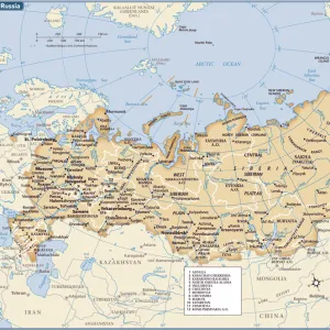
Jigsaw Puzzle : Map of european part of Russia 1900


![]()
Jigsaw Puzzles From Fine Art Storehouse
Map of european part of Russia 1900
Meyers hand-Atlas Leipzig und Wien Verlag des Bibliographischen Instituts 1900
Unleash your creativity and transform your space into a visual masterpiece!
THEPALMER
Media ID 18106891
© 2014 Roberto Adrian Photography
Jigsaw Puzzle (520 Pieces)
Discover the historical charm of Europe's largest country with our intricately detailed jigsaw puzzle from the Media Storehouse collection. Featuring a captivating map of the European part of Russia, as it appeared in 1900 from THEPALMER's "Fine Art Storehouse" series published by Meyers Hand-Atlas Leipzig und Wien Verlag des Bibliographischen Instituts, this puzzle invites you on a journey through time. With authentic cartography and rich historical context, piecing together this puzzle will transport you back to an era of imperial Russia. Experience the joy of discovery and the satisfaction of completing a high-quality, hands-on project. Engage your mind and expand your knowledge with the Media Storehouse Map of European Russia 1900 jigsaw puzzle.
Made in the USA, 520-piece puzzles measure 16" x 20" (40.6 x 50.8 cm). Every puzzle is meticulously printed on glossy photo paper, which has a strong 1.33 mm thickness. Delivered in a black storage cardboard box, these puzzles are both stylish and practical. (Note: puzzles contain small parts and are not suitable for children under 3 years of age.)
Jigsaw Puzzles are an ideal gift for any occasion
Estimated Product Size is 40.5cm x 50.8cm (15.9" x 20")
These are individually made so all sizes are approximate
Artwork printed orientated as per the preview above, with landscape (horizontal) or portrait (vertical) orientation to match the source image.
FEATURES IN THESE COLLECTIONS
> Europe
> Russia
> Related Images
EDITORS COMMENTS
This print showcases a historical gem, the "Map of European Part of Russia 1900". Taken from Meyers Hand-Atlas Leipzig und Wien Verlag des Bibliographischen Instituts in 1900, this piece offers a fascinating glimpse into the past. The map itself is an intricate masterpiece, meticulously detailing the vast expanse of Russia's European region during that era. The fine craftsmanship and attention to detail are evident in every inch of this print. From the delicate lines tracing rivers and borders to the carefully labeled cities and towns, it transports us back to a time when cartography was both art and science. The rich earthy tones used in this reproduction add depth and warmth to its overall aesthetic. As we examine this map closely, we can't help but marvel at how much has changed over the years. It serves as a visual reminder of shifting political boundaries, cultural transformations, and historical events that have shaped Europe's largest country. "The Map of European Part of Russia 1900" by THEPALMER is not just a decorative piece; it is also an educational tool that sparks curiosity about our shared history. Whether displayed in homes or offices, it invites viewers on an immersive journey through time while igniting conversations about geography and geopolitics. With its timeless appeal and artistic allure, this print captures the essence of an era long gone yet forever preserved within its intricate details.
MADE IN THE USA
Safe Shipping with 30 Day Money Back Guarantee
FREE PERSONALISATION*
We are proud to offer a range of customisation features including Personalised Captions, Color Filters and Picture Zoom Tools
SECURE PAYMENTS
We happily accept a wide range of payment options so you can pay for the things you need in the way that is most convenient for you
* Options may vary by product and licensing agreement. Zoomed Pictures can be adjusted in the Basket.