Jigsaw Puzzle > North America > Haiti > Maps
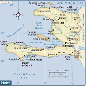
Jigsaw Puzzle : Haiti Puerto Rico map 1896


![]()
Jigsaw Puzzles from Fine Art Storehouse
Haiti Puerto Rico map 1896
Andres Allgemeiner Handatlas - Bielefeld und Leipzig 1896
Unleash your creativity and transform your space into a visual masterpiece!
THEPALMER
Media ID 18357023
Jigsaw Puzzle (1014 Pieces)
Discover the rich history of the Caribbean with the Media Storehouse Jigsaw Puzzle featuring the "Haiti Puerto Rico Map 1896" by THEPALMER from Fine Art Storehouse. This intricately detailed puzzle is a piece of history brought to life, showcasing the map from Andres Allgemeiner Handatlas published in Bielefeld and Leipzig in 1896. Immerse yourself in the puzzle-solving experience and explore the political boundaries of Haiti and Puerto Rico during this fascinating era. A perfect addition to any home or office, this puzzle is a great way to challenge your mind and expand your knowledge. Puzzle pieces are made from high-quality, durable material for a satisfying puzzle-solving experience.
Made in the USA, 1014-piece puzzles measure 20" x 30" (50.8 x 76.2 cm). Every puzzle is meticulously printed on glossy photo paper, which has a strong 1.33 mm thickness. Delivered in a black storage cardboard box, these puzzles are both stylish and practical. (Note: puzzles contain small parts and are not suitable for children under 3 years of age.)
Jigsaw Puzzles are an ideal gift for any occasion
Estimated Product Size is 76cm x 50.8cm (29.9" x 20")
These are individually made so all sizes are approximate
Artwork printed orientated as per the preview above, with landscape (horizontal) orientation to match the source image.
FEATURES IN THESE COLLECTIONS
> Maps and Charts
> Related Images
> North America
> Haiti
> Maps
> North America
> Haiti
> Related Images
> North America
> Puerto Rico
> Maps
> North America
> Puerto Rico
> Related Images
EDITORS COMMENTS
This print showcases a historical gem - the Haiti Puerto Rico map from 1896, sourced from Andres Allgemeiner Handatlas. A true testament to the intricate artistry of cartography, this vintage piece takes us back in time to an era when maps were meticulously hand-drawn and beautifully detailed. The map itself is a fascinating fusion of geography and history, offering a glimpse into the past boundaries and topographical features of both Haiti and Puerto Rico. With its delicate lines and carefully shaded regions, it not only serves as a navigational tool but also as an artistic masterpiece that captures the essence of these Caribbean islands. As we admire this print by THEPALMER, we are reminded of how far we have come in terms of technological advancements in mapping techniques. Yet, there is an undeniable charm in witnessing the craftsmanship involved in creating such intricate maps manually. Whether you are a history enthusiast or simply appreciate fine art, this print allows you to immerse yourself in the rich cultural heritage of Haiti and Puerto Rico. It acts as a window into their pasts while simultaneously serving as an exquisite decorative piece for any space. With every glance at this remarkable artwork, one can't help but feel connected to these vibrant lands with their unique stories waiting to be explored.
MADE IN THE USA
Safe Shipping with 30 Day Money Back Guarantee
FREE PERSONALISATION*
We are proud to offer a range of customisation features including Personalised Captions, Color Filters and Picture Zoom Tools
SECURE PAYMENTS
We happily accept a wide range of payment options so you can pay for the things you need in the way that is most convenient for you
* Options may vary by product and licensing agreement. Zoomed Pictures can be adjusted in the Basket.