Jigsaw Puzzle > Fine Art Storehouse > Map
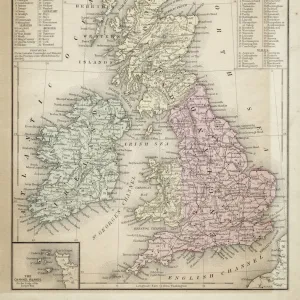
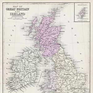
Jigsaw Puzzle : British isles map 1898


![]()
Jigsaw Puzzles From Fine Art Storehouse
British isles map 1898
Unleash your creativity and transform your space into a visual masterpiece!
THEPALMER
Media ID 14549479
© This content is subject to copyright
Jigsaw Puzzle (520 Pieces)
Discover the rich history of the British Isles with our exquisite jigsaw puzzle from ThePalmer's Fine Art Storehouse collection. This intricately detailed puzzle features a captivating map of the British Isles from 1898. Each piece is meticulously cut to fit seamlessly into the larger image, providing a satisfying puzzle experience for all ages. Travel back in time and explore the historical geography of the British Isles with this beautiful and challenging puzzle.
Made in the USA, 520-piece puzzles measure 16" x 20" (40.6 x 50.8 cm). Every puzzle is meticulously printed on glossy photo paper, which has a strong 1.33 mm thickness. Delivered in a black storage cardboard box, these puzzles are both stylish and practical. (Note: puzzles contain small parts and are not suitable for children under 3 years of age.)
Jigsaw Puzzles are an ideal gift for any occasion
Estimated Product Size is 40.5cm x 50.8cm (15.9" x 20")
These are individually made so all sizes are approximate
Artwork printed orientated as per the preview above, with landscape (horizontal) or portrait (vertical) orientation to match the source image.
FEATURES IN THESE COLLECTIONS
> Fine Art Storehouse
> Map
> Historical Maps
EDITORS COMMENTS
This print showcases a meticulously detailed map of the British Isles from the year 1898. Created by THEPALMER, this piece captures the essence of historical cartography with its intricate lines and exquisite craftsmanship. The map itself is a testament to the rich heritage and cultural significance of the British Isles. As we delve into this snapshot of history, our eyes are immediately drawn to the beautifully rendered coastlines, rivers, and mountains that define these iconic lands. Each contour tells a story, revealing centuries-old towns and cities nestled amidst lush green landscapes. It is as if time has stood still within these borders. The sepia tones lend an air of nostalgia to this artwork, evoking a sense of reverence for times gone by. One can almost imagine explorers poring over similar maps in search of new territories or sailors relying on them for safe passage across treacherous waters. Beyond its aesthetic appeal lies an educational treasure trove; every inch teems with historical significance waiting to be discovered. This image serves as both a visual delight and an invaluable resource for historians, geographers, or anyone seeking insight into Britain's past. Whether displayed in a study room or adorning the walls of an art enthusiast's collection, this print invites us to explore not only geographical boundaries but also our own curiosity about how our world has evolved over time.
MADE IN THE USA
Safe Shipping with 30 Day Money Back Guarantee
FREE PERSONALISATION*
We are proud to offer a range of customisation features including Personalised Captions, Color Filters and Picture Zoom Tools
SECURE PAYMENTS
We happily accept a wide range of payment options so you can pay for the things you need in the way that is most convenient for you
* Options may vary by product and licensing agreement. Zoomed Pictures can be adjusted in the Basket.