Jigsaw Puzzle > Maps and Charts > Americas
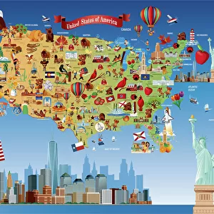
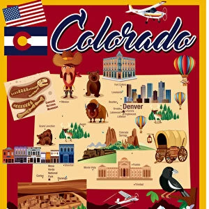
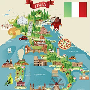
Jigsaw Puzzle : Cartoon map of America


![]()
Jigsaw Puzzles From Fine Art Storehouse
Cartoon map of America
Unleash your creativity and transform your space into a visual masterpiece!
Media ID 14637241
Jigsaw Puzzle (520 Pieces)
Discover the fun and excitement of piecing together the Cartoon Map of America from Media Storehouse's Fine Art Jigsaw Puzzles collection. This whimsical and vibrant puzzle features a unique and playful representation of the United States. Each piece is meticulously designed to fit perfectly with the puzzle's shape and image, ensuring a satisfying and engaging puzzle-solving experience for all ages. Bring some color and creativity into your home with this delightful addition to your Media Storehouse jigsaw puzzle collection.
Made in the USA, 520-piece puzzles measure 16" x 20" (40.6 x 50.8 cm). Every puzzle is meticulously printed on glossy photo paper, which has a strong 1.33 mm thickness. Delivered in a black storage cardboard box, these puzzles are both stylish and practical. (Note: puzzles contain small parts and are not suitable for children under 3 years of age.)
Jigsaw Puzzles are an ideal gift for any occasion
Estimated Product Size is 40.5cm x 50.8cm (15.9" x 20")
These are individually made so all sizes are approximate
Artwork printed orientated as per the preview above, with landscape (horizontal) or portrait (vertical) orientation to match the source image.
FEATURES IN THESE COLLECTIONS
> Fine Art Storehouse
> Map
> Cartoon Maps
> Maps and Charts
> Related Images
EDITORS COMMENTS
This print showcases a whimsical and vibrant "Cartoon map of America". Bursting with color and creativity, this artwork takes us on an imaginative journey across the vast expanse of the United States. From coast to coast, every state is playfully depicted with its distinctive landmarks, iconic symbols, and cultural references. The artist's skillful use of cartoonish elements adds a delightful touch to this map, making it both visually appealing and engaging. Each state comes alive as characters frolic amidst their unique landscapes - mountains majestically rise in Colorado while palm trees sway in sunny California. The Great Lakes sparkle with charm, inviting us to explore their shores. Beyond its artistic appeal, this print also serves as an educational tool for geography enthusiasts or curious minds seeking to learn more about America's diverse regions. It sparks conversations about history and culture while igniting our sense of wanderlust. Whether displayed in a classroom or adorning the walls of a living room, this Cartoon Map of America print brings joy and curiosity into any space. Its cheerful colors evoke feelings of nostalgia for childhood adventures while reminding us that there is always something new waiting to be discovered within our own backyard.
MADE IN THE USA
Safe Shipping with 30 Day Money Back Guarantee
FREE PERSONALISATION*
We are proud to offer a range of customisation features including Personalised Captions, Color Filters and Picture Zoom Tools
SECURE PAYMENTS
We happily accept a wide range of payment options so you can pay for the things you need in the way that is most convenient for you
* Options may vary by product and licensing agreement. Zoomed Pictures can be adjusted in the Basket.