Jigsaw Puzzle > North America > United States of America > Maps
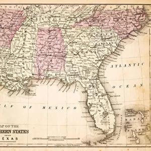
Jigsaw Puzzle : Map of Railroads USA 1883


![]()
Jigsaw Puzzles From Fine Art Storehouse
Map of Railroads USA 1883
Warrens Common School Geography
Unleash your creativity and transform your space into a visual masterpiece!
THEPALMER
Media ID 13669349
© This content is subject to copyright
Paper Rail Transportation Railroad Track
Jigsaw Puzzle (520 Pieces)
Discover the intriguing history of railroads in America with our captivating jigsaw puzzle from Media Storehouse and Fine Art Storehouse, featuring the detailed and vintage "Map of Railroads USA 1883" by THEPALMER from Warrens Common School Geography. This puzzle presents an engaging challenge for puzzle enthusiasts of all ages, as they piece together the intricate network of railroads that shaped the country's landscape over a century ago. Immerse yourself in the rich history of transportation and geography as you bring this fascinating puzzle to life.
Made in the USA, 520-piece puzzles measure 16" x 20" (40.6 x 50.8 cm). Every puzzle is meticulously printed on glossy photo paper, which has a strong 1.33 mm thickness. Delivered in a black storage cardboard box, these puzzles are both stylish and practical. (Note: puzzles contain small parts and are not suitable for children under 3 years of age.)
Jigsaw Puzzles are an ideal gift for any occasion
Estimated Product Size is 50.8cm x 40.5cm (20" x 15.9")
These are individually made so all sizes are approximate
Artwork printed orientated as per the preview above, with landscape (horizontal) or portrait (vertical) orientation to match the source image.
FEATURES IN THESE COLLECTIONS
> Maps and Charts
> Related Images
> North America
> United States of America
> Maps
EDITORS COMMENTS
This print titled "Map of Railroads USA 1883" takes us on a journey back in time to the late 19th century. A relic from Warrens Common School Geography, this horizontal image showcases the intricate network of railroads that crisscrossed the vast expanse of North America's United States. Printed on aged paper, this antique map carries an air of nostalgia and historical significance. The meticulously engraved illustration captures every detail of the railroad tracks, showcasing their importance in shaping America's physical geography during that era. The artistry behind this piece is evident in its exquisite cartography and precision engraving. It serves as a testament to the skillful craftsmanship that went into creating such comprehensive maps before modern technology took over. As we gaze upon this remarkable image, we are transported to a time when rail transportation was at its peak, connecting cities and towns across the nation like never before. It reminds us of how these iron arteries transformed not only travel but also trade and communication throughout America. "The Map of Railroads USA 1883" by THEPALMER invites us to appreciate both the beauty and historical significance embedded within old maps. This stunning print serves as a reminder of our past while igniting curiosity about how far we have come since those early days of rail transportation.
MADE IN THE USA
Safe Shipping with 30 Day Money Back Guarantee
FREE PERSONALISATION*
We are proud to offer a range of customisation features including Personalised Captions, Color Filters and Picture Zoom Tools
SECURE PAYMENTS
We happily accept a wide range of payment options so you can pay for the things you need in the way that is most convenient for you
* Options may vary by product and licensing agreement. Zoomed Pictures can be adjusted in the Basket.