Jigsaw Puzzle > North America > Related Images
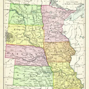
Jigsaw Puzzle : Map of Central States USA 1883


![]()
Jigsaw Puzzles From Fine Art Storehouse
Map of Central States USA 1883
Warrens Common School Geography
Unleash your creativity and transform your space into a visual masterpiece!
THEPALMER
Media ID 13669353
© This content is subject to copyright
Illinois Indiana Massachusetts Michigan Ohio Paper Wisconsin
Jigsaw Puzzle (520 Pieces)
Discover the intrigue of history with our captivating Map of Central States USA 1883 jigsaw puzzle from ThePalmer at Media Storehouse. This Fine Art Storehouse masterpiece, inspired by Warrens Common School Geography, transports you back in time to the late 19th century. With intricate details and vibrant colors, this puzzle offers hours of engaging entertainment for puzzle enthusiasts and history buffs alike. Immerse yourself in the intricacies of geography and the charm of a bygone era – solve the puzzle and unveil the rich history hidden within.
Made in the USA, 520-piece puzzles measure 16" x 20" (40.6 x 50.8 cm). Every puzzle is meticulously printed on glossy photo paper, which has a strong 1.33 mm thickness. Delivered in a black storage cardboard box, these puzzles are both stylish and practical. (Note: puzzles contain small parts and are not suitable for children under 3 years of age.)
Jigsaw Puzzles are an ideal gift for any occasion
Estimated Product Size is 40.5cm x 50.8cm (15.9" x 20")
These are individually made so all sizes are approximate
Artwork printed orientated as per the preview above, with landscape (horizontal) or portrait (vertical) orientation to match the source image.
FEATURES IN THESE COLLECTIONS
> Fine Art Storehouse
> The Magical World of Illustration
> Palmer Illustrated Collection
> Fine Art Storehouse
> Map
> Historical Maps
> Fine Art Storehouse
> Map
> USA Maps
> North America
> Related Images
EDITORS COMMENTS
This print takes us back in time to the year 1883, showcasing a beautifully detailed "Map of Central States USA". A product of Warrens Common School Geography, this vintage piece offers a glimpse into the past when paper maps were essential tools for understanding our world. The vertical composition allows us to explore the vast expanse of North America, with particular focus on states such as Illinois, Michigan, Indiana, Wisconsin, Ohio, and Massachusetts. The aged appearance adds an air of authenticity to this historical artifact. Its physical geography is meticulously depicted through intricate engravings and illustrations that bring life to every contour and waterway. As we study this antique cartographic gem by THEPALMER from Fine Art Storehouse, we are transported back to a time when exploration was still unfolding across these lands. This image serves as a reminder of how far we have come in terms of technological advancements in mapping and navigation. It sparks curiosity about the challenges faced by early explorers who relied on such maps during their journeys. Whether displayed in an educational setting or cherished within a personal collection, this timeless piece invites contemplation about our ever-changing world while celebrating the artistry involved in creating these engraved images that continue to captivate us today.
MADE IN THE USA
Safe Shipping with 30 Day Money Back Guarantee
FREE PERSONALISATION*
We are proud to offer a range of customisation features including Personalised Captions, Color Filters and Picture Zoom Tools
SECURE PAYMENTS
We happily accept a wide range of payment options so you can pay for the things you need in the way that is most convenient for you
* Options may vary by product and licensing agreement. Zoomed Pictures can be adjusted in the Basket.