Jigsaw Puzzle > Asia > Philippines > Maps
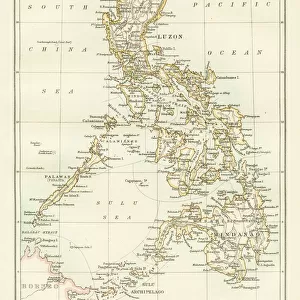
Jigsaw Puzzle : Map of Manila, c.1900 (engraving)
")
")


![]()
Jigsaw Puzzles From Fine Art Finder
Map of Manila, c.1900 (engraving)
533340 Map of Manila, c.1900 (engraving); (add.info.: Map of Manila Bay, Philippines, circa 1902, from the 10th edition of Encyclopaedia Britannica.); Encyclopaedia Britannica/UIG
Media ID 38139010
© Encyclopaedia Britannica/UIG / Bridgeman Images
1902 19th Century Style Capital Cities Filipino Guidance Illustration Technique Manila Navigational Equipment Old Fashioned Philippines Physical Geography South China Sea South East Asia The Past Western Script Luzon Island Manila Bay
Jigsaw Puzzle (520 Pieces)
Discover the beauty and history of Manila with our captivating jigsaw puzzle featuring a vintage map from c.1900. Perfect for hours of entertainment and a unique piece of art to display in your home.
Made in the USA, 520-piece puzzles measure 16" x 20" (40.6 x 50.8 cm). Every puzzle is meticulously printed on glossy photo paper, which has a strong 1.33 mm thickness. Delivered in a black storage cardboard box, these puzzles are both stylish and practical. (Note: puzzles contain small parts and are not suitable for children under 3 years of age.)
Jigsaw Puzzles are an ideal gift for any occasion
Estimated Product Size is 40.5cm x 50.8cm (15.9" x 20")
These are individually made so all sizes are approximate
Artwork printed orientated as per the preview above, with landscape (horizontal) or portrait (vertical) orientation to match the source image.
FEATURES IN THESE COLLECTIONS
> Fine Art Finder
> Temp Classification
> Asia
> China
> Lakes
> Related Images
> Asia
> Philippines
> Lakes
> Related Images
> Asia
> Philippines
> Manila
> Asia
> Philippines
> Maps
> Asia
> Philippines
> Related Images
> Maps and Charts
> Related Images
EDITORS COMMENTS
This stunning engraving of a Map of Manila, circa 1900, offers a glimpse into the past with its intricate details and historical significance. The map showcases the capital city of the Philippines, Manila Bay, and Luzon Island in exquisite 19th-century style.
As we study this piece of cartography, we are transported back in time to an era of exploration and discovery. The Western script used on the map adds to its old-fashioned charm, while the coastline and navigational equipment depicted provide insight into how sailors once charted their course through these waters.
The Map of Manila is not just a geographical representation but also a window into the physical geography of South East Asia. It serves as a reminder of the rich history and cultural heritage that defines this region.
With no people present in the image, we are left to marvel at the intricacy and attention to detail put into creating this illustration. From Manila Bay to Lake Manilla, every feature is meticulously rendered for both practical guidance and aesthetic pleasure.
This print from Fine Art Finder is more than just a map – it is a work of art that captures the essence of Manila in all its glory.
MADE IN THE USA
Safe Shipping with 30 Day Money Back Guarantee
FREE PERSONALISATION*
We are proud to offer a range of customisation features including Personalised Captions, Color Filters and Picture Zoom Tools
SECURE PAYMENTS
We happily accept a wide range of payment options so you can pay for the things you need in the way that is most convenient for you
* Options may vary by product and licensing agreement. Zoomed Pictures can be adjusted in the Basket.