Jigsaw Puzzle > North America > United States of America > Lakes > Lake Erie
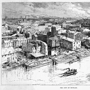
Jigsaw Puzzle : map of Detroit, c.1900 (engraving)
")
")


![]()
Jigsaw Puzzles From Fine Art Finder
map of Detroit, c.1900 (engraving)
532755 map of Detroit, c.1900 (engraving); (add.info.: Map of Detroit, Michigan, and the Detroit River, circa 1900, from the 10th edition of Encyclopaedia Britannica.); Encyclopaedia Britannica/UIG
Media ID 38309798
© Encyclopaedia Britannica/UIG / Bridgeman Images
1900 19th Century Style City Map Detroit Direction Geographical Border Guidance Illustration Technique Lake Erie Michigan Navigational Equipment Number Old Fashioned Physical Geography The Past Western Script Detroit River
Jigsaw Puzzle (1014 Pieces)
Discover the charm of vintage maps with our Media Storehouse jigsaw puzzle featuring a detailed engraving of "Map of Detroit, c.1900." Piece together this historical artwork and explore the streets and landmarks of Detroit from over a century ago. Perfect for history buffs and puzzle enthusiasts alike!
Made in the USA, 1014-piece puzzles measure 20" x 30" (50.8 x 76.2 cm). Every puzzle is meticulously printed on glossy photo paper, which has a strong 1.33 mm thickness. Delivered in a black storage cardboard box, these puzzles are both stylish and practical. (Note: puzzles contain small parts and are not suitable for children under 3 years of age.)
Jigsaw Puzzles are an ideal gift for any occasion
Estimated Product Size is 50.8cm x 76cm (20" x 29.9")
These are individually made so all sizes are approximate
Artwork printed orientated as per the preview above, with portrait (vertical) orientation to match the source image.
FEATURES IN THESE COLLECTIONS
> Fine Art Finder
> Temp Classification
> Maps and Charts
> Related Images
> North America
> United States of America
> Lakes
> Lake Erie
> North America
> United States of America
> Lakes
> Lake Michigan
> North America
> United States of America
> Lakes
> Related Images
> North America
> United States of America
> Maps
> North America
> United States of America
> Michigan
> Detroit
> North America
> United States of America
> Michigan
> Related Images
EDITORS COMMENTS
This stunning engraving of a map of Detroit, circa 1900, offers a glimpse into the past and showcases the intricate details of this historic city. The Western script used to label various landmarks and geographical features adds an old-fashioned charm to the piece, while the navigational equipment depicted hints at the importance of exploration during this time period.
The map includes not only Detroit itself but also the Detroit River, providing valuable insight into the layout and geography of the area. The vertical orientation allows for easy navigation and guidance, making it a practical tool for anyone looking to explore or understand this bustling city.
With Lake Erie visible in the background and detailed illustrations of riverbanks and physical geography throughout, this map is both informative and visually captivating. It serves as a reminder of how far cartography has come since the 19th century while also highlighting the timeless beauty of hand-drawn maps.
Whether you're a history buff, a fan of vintage illustration techniques, or simply someone with an appreciation for artistry, this print is sure to make a statement in any space. Add it to your collection today and let its historical significance transport you back in time to turn-of-the-century Detroit.
MADE IN THE USA
Safe Shipping with 30 Day Money Back Guarantee
FREE PERSONALISATION*
We are proud to offer a range of customisation features including Personalised Captions, Color Filters and Picture Zoom Tools
SECURE PAYMENTS
We happily accept a wide range of payment options so you can pay for the things you need in the way that is most convenient for you
* Options may vary by product and licensing agreement. Zoomed Pictures can be adjusted in the Basket.