Jigsaw Puzzle > Arts > Artists > O > Abraham Ortelius
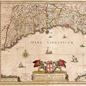
Jigsaw Puzzle : Map of Tuscany in Italy, 1570 (engraving)
")

")


![]()
Jigsaw Puzzles From Fine Art Finder
Map of Tuscany in Italy, 1570 (engraving)
LRI4704766 Map of Tuscany in Italy, 1570 (engraving) by Ortelius, Abraham (1527-98); Museo Navale di Pegli, Genoa, Italy; (add.info.: Thusciae. Descriptio auctore Hieronymo Bellamarto Geography map of the territory of Tuscany in Italy from " Theatrum Orbis Terrarum" by Abraham Ortelius (Oertel, Ortell or Ortel, 1527-1598), 1570. Genova, Museo Navale); Luisa Ricciarini; Flemish, out of copyright
Media ID 22837774
© Luisa Ricciarini / Bridgeman Images
Jigsaw Puzzle (1014 Pieces)
Discover the rich history and beauty of Tuscany with our exquisite jigsaw puzzle from Media Storehouse. Featuring an intricately detailed, vintage engraving of a Map of Tuscany in Italy, dating back to 1570. This captivating puzzle, inspired by the work of renowned cartographer Abraham Ortelius, invites you to embark on a journey through time. Immerse yourself in the intricacies of this fine art masterpiece, brought to you by Fine Art Finder (LRI4704766), and bring the ancient charm of Tuscany into your home.
Made in the USA, 1014-piece puzzles measure 20" x 30" (50.8 x 76.2 cm). Every puzzle is meticulously printed on glossy photo paper, which has a strong 1.33 mm thickness. Delivered in a black storage cardboard box, these puzzles are both stylish and practical. (Note: puzzles contain small parts and are not suitable for children under 3 years of age.)
Jigsaw Puzzles are an ideal gift for any occasion
Estimated Product Size is 76cm x 50.8cm (29.9" x 20")
These are individually made so all sizes are approximate
Artwork printed orientated as per the preview above, with landscape (horizontal) orientation to match the source image.
FEATURES IN THESE COLLECTIONS
> Arts
> Artists
> O
> Abraham Ortelius
> Europe
> Italy
> Liguria
> Genoa
> Europe
> Italy
> Tuscany
> Related Images
> Maps and Charts
> Abraham Ortelius
> Maps and Charts
> Italy
> Maps and Charts
> Related Images
EDITORS COMMENTS
This print showcases a remarkable piece of history, the "Map of Tuscany in Italy, 1570". Created by Abraham Ortelius, a renowned Flemish cartographer and geographer, this engraving is a part of his famous work "Theatrum Orbis Terrarum" considered to be the first modern atlas. The map provides an intricate depiction of the territory of Tuscany during the late 16th century. It offers viewers a glimpse into the geographical features and boundaries that shaped this beautiful region in Italy. The attention to detail is evident as every river, mountain range, and city is meticulously illustrated. Ortelius' expertise in cartography shines through as he accurately captures Tuscany's landscape with precision and artistry. This particular print can be found at Museo Navale di Pegli in Genoa, Italy. Luisa Ricciarini has skillfully captured this historical artifact through her lens, bringing it to life for all admirers of fine art. Her photograph allows us to appreciate not only Ortelius' craftsmanship but also Ricciarini's talent for capturing details and preserving them for future generations. As we gaze upon this image, we are transported back in time to explore Tuscany as it once was - its rolling hillsides dotted with charming villages and vineyards that have made it one of Italy's most beloved regions.
MADE IN THE USA
Safe Shipping with 30 Day Money Back Guarantee
FREE PERSONALISATION*
We are proud to offer a range of customisation features including Personalised Captions, Color Filters and Picture Zoom Tools
SECURE PAYMENTS
We happily accept a wide range of payment options so you can pay for the things you need in the way that is most convenient for you
* Options may vary by product and licensing agreement. Zoomed Pictures can be adjusted in the Basket.