Jigsaw Puzzle > Europe > United Kingdom > England > London > Museums > National Maritime Museum
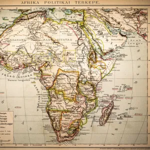
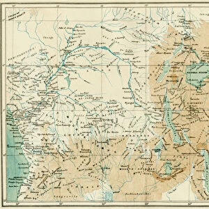
Jigsaw Puzzle : Chart of Congo and Angola, Africa, 1670 (engraving)
")
")


![]()
Jigsaw Puzzles From Fine Art Finder
Chart of Congo and Angola, Africa, 1670 (engraving)
7339514 Chart of Congo and Angola, Africa, 1670 (engraving) by Ogilby, John (1600-1676); 29x35 cm; National Maritime Museum, London, UK; (add.info.: Creator: John Ogilby
Sea decorated with ships. Land decorated with animals. Cartouche with Africans and European trader.); © National Maritime Museum, Greenwich, London
Media ID 38101536
© © National Maritime Museum, Greenwich, London / Bridgeman Images
Jigsaw Puzzle (520 Pieces)
Embark on a journey through history with our captivating jigsaw puzzle featuring the "Chart of Congo and Angola, Africa, 1670" by Bridgeman Images. Dive into the intricate details of this engraving by John Ogilby and piece together a beautiful depiction of African geography. Perfect for history buffs and puzzle enthusiasts alike!
Made in the USA, 520-piece puzzles measure 16" x 20" (40.6 x 50.8 cm). Every puzzle is meticulously printed on glossy photo paper, which has a strong 1.33 mm thickness. Delivered in a black storage cardboard box, these puzzles are both stylish and practical. (Note: puzzles contain small parts and are not suitable for children under 3 years of age.)
Jigsaw Puzzles are an ideal gift for any occasion
Estimated Product Size is 50.8cm x 40.5cm (20" x 15.9")
These are individually made so all sizes are approximate
Artwork printed orientated as per the preview above, with landscape (horizontal) or portrait (vertical) orientation to match the source image.
FEATURES IN THESE COLLECTIONS
> Africa
> Angola
> Related Images
> Arts
> Artists
> O
> John Ogilby
> Arts
> Artists
> W
> John White
> Europe
> France
> Canton
> Landes
> Europe
> United Kingdom
> England
> London
> Boroughs
> Greenwich
> Europe
> United Kingdom
> England
> London
> Museums
> Greenwich Heritage Centre
> Europe
> United Kingdom
> England
> London
> Museums
> National Maritime Museum
> Europe
> United Kingdom
> England
> London
> Towns
> Greenwich
> Europe
> United Kingdom
> Heritage Sites
> Maritime Greenwich
EDITORS COMMENTS
This stunning engraving from 1670 depicts a detailed Chart of Congo and Angola in Africa, created by the talented John Ogilby. The intricate map showcases the sea adorned with ships and the land decorated with various animals, providing a fascinating glimpse into the geography of these regions during the 17th century.
One of the most striking features of this print is the cartouche depicting Africans alongside a European trader, highlighting the complex interactions between different cultures and peoples at that time. The contrast between black and white in this engraving adds to its visual impact, drawing viewers into a world rich with history and exploration.
As you study this piece closely, you can almost imagine yourself sailing through these waters or traversing across these lands centuries ago. The attention to detail in Ogilby's work is truly remarkable, capturing not just geographical accuracy but also cultural nuances that make this map come alive.
Displayed at the National Maritime Museum in London, this Chart of Congo and Angola serves as both a historical artifact and a work of art. It invites us to reflect on our past while marveling at the skill and creativity of those who came before us.
MADE IN THE USA
Safe Shipping with 30 Day Money Back Guarantee
FREE PERSONALISATION*
We are proud to offer a range of customisation features including Personalised Captions, Color Filters and Picture Zoom Tools
SECURE PAYMENTS
We happily accept a wide range of payment options so you can pay for the things you need in the way that is most convenient for you
* Options may vary by product and licensing agreement. Zoomed Pictures can be adjusted in the Basket.