Jigsaw Puzzle > Europe > United Kingdom > England > Related Images
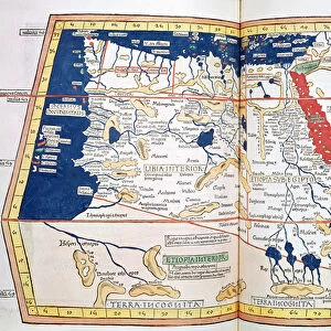
Jigsaw Puzzle : Map of the British Isles, from Geographia (vellum)
")
")


![]()
Jigsaw Puzzles From Fine Art Finder
Map of the British Isles, from Geographia (vellum)
XIR243795 Map of the British Isles, from Geographia (vellum) by Ptolemy (Claudius Ptolemaeus of Alexandria)(c.90-168)(after); Biblioteca Marciana, Venice, Italy; Greek, out of copyright
Media ID 12769915
© www.bridgemanimages.com
Jigsaw Puzzle (520 Pieces)
Discover the rich history and intricate details of the British Isles with our exquisite jigsaw puzzles from Media Storehouse. This beautiful puzzle, featuring the "Map of the British Isles, from Geographia (vellum)" by Ptolemy, transports you back in time. Reproduced from the ancient Greek cartographer's renowned work, this puzzle is a captivating blend of history and entertainment. With intricately carved pieces, solving this puzzle is not just about completion, but also a journey through the ages. Experience the allure of fine art and the thrill of puzzle-solving with Media Storehouse.
Made in the USA, 520-piece puzzles measure 16" x 20" (40.6 x 50.8 cm). Every puzzle is meticulously printed on glossy photo paper, which has a strong 1.33 mm thickness. Delivered in a black storage cardboard box, these puzzles are both stylish and practical. (Note: puzzles contain small parts and are not suitable for children under 3 years of age.)
Jigsaw Puzzles are an ideal gift for any occasion
Estimated Product Size is 40.5cm x 50.8cm (15.9" x 20")
These are individually made so all sizes are approximate
Artwork printed orientated as per the preview above, with landscape (horizontal) or portrait (vertical) orientation to match the source image.
FEATURES IN THESE COLLECTIONS
> Fine Art Finder
> Artists
> P
> Ptolemy (c.90-168)(after) Ptolemy
> Fine Art Finder
> Artists
> Ptolemy (c.90-168)(after)
> Europe
> Italy
> Related Images
> Europe
> United Kingdom
> England
> Related Images
> Europe
> United Kingdom
> Wales
> Related Images
EDITORS COMMENTS
This print showcases a remarkable piece of history - the Map of the British Isles from Geographia, created by Ptolemy. Dating back to ancient times, this vellum manuscript is an invaluable artifact that offers a glimpse into the geographical knowledge and cartographic skills of its time. The intricate details on this map are awe-inspiring. It beautifully depicts not only England, Scotland, Wales, and Ireland but also various other islands surrounding them. The precision with which each coastline is drawn highlights the meticulousness with which Ptolemy approached his work. As we delve deeper into this image, we can't help but marvel at how far our understanding of geography has come since Ptolemy's era. This medieval masterpiece serves as a testament to human curiosity and exploration throughout history. Preserved in the Biblioteca Marciana in Venice, Italy, this Greek manuscript holds immense cultural significance. Its availability for public viewing allows us to appreciate both its artistic beauty and historical importance. Through this photograph print from Fine Art Finder by www. bridgemanimages. com, we have an opportunity to bring home a piece of ancient wisdom and immerse ourselves in the rich tapestry of human knowledge that spans centuries. Let it serve as a reminder that even though our world may change rapidly over time, there will always be treasures like these maps that connect us to our past and inspire us for generations to come.
MADE IN THE USA
Safe Shipping with 30 Day Money Back Guarantee
FREE PERSONALISATION*
We are proud to offer a range of customisation features including Personalised Captions, Color Filters and Picture Zoom Tools
SECURE PAYMENTS
We happily accept a wide range of payment options so you can pay for the things you need in the way that is most convenient for you
* Options may vary by product and licensing agreement. Zoomed Pictures can be adjusted in the Basket.