Jigsaw Puzzle > Arts > Artists > J > Thomas Jones
Jigsaw Puzzle : Map Of The World (engraving)
")
")


![]()
Jigsaw Puzzles From Fine Art Finder
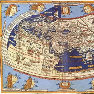
Map Of The World (engraving)
976411 Map Of The World (engraving) by English School, (18th century); Private Collection; (add.info.: Map Of The World, from an ancient manuscript in the Cotton Library, marked Tiberius BV. Illustration for The Chronicle of England by Joseph Strutt (Thomas Jones, 1778).); © Look and Learn
Media ID 23525236
© Look and Learn / Bridgeman Images
Jigsaw Puzzle (520 Pieces)
Discover the wonders of our interconnected world with the Media Storehouse Jigsaw Puzzle featuring the captivating Map Of The World (engraving) by Bridgeman Images from Fine Art Finder. This intricately detailed puzzle, inspired by an 18th-century English School map from the Cotton Library, invites you on a journey of exploration and discovery. With each piece placed, the ancient manuscript's intricate lines and engravings come to life, revealing a beautiful representation of the world as it was once known. Immerse yourself in history and geography, and unleash your inner puzzle solver with this captivating and educational puzzle.
Made in the USA, 520-piece puzzles measure 16" x 20" (40.6 x 50.8 cm). Every puzzle is meticulously printed on glossy photo paper, which has a strong 1.33 mm thickness. Delivered in a black storage cardboard box, these puzzles are both stylish and practical. (Note: puzzles contain small parts and are not suitable for children under 3 years of age.)
Jigsaw Puzzles are an ideal gift for any occasion
Estimated Product Size is 40.5cm x 50.8cm (15.9" x 20")
These are individually made so all sizes are approximate
Artwork printed orientated as per the preview above, with landscape (horizontal) or portrait (vertical) orientation to match the source image.
FEATURES IN THESE COLLECTIONS
> Arts
> Artists
> J
> Thomas Jones
> Arts
> Artists
> N
> Thomas North
> Europe
> Germany
> Related Images
> Europe
> United Kingdom
> England
> Maps
> Europe
> United Kingdom
> Maps
> Maps and Charts
> Early Maps
> Maps and Charts
> Related Images
EDITORS COMMENTS
This print showcases a remarkable engraving titled "Map Of The World" by an anonymous English School artist from the 18th century. Housed in a private collection, this exquisite piece originates from an ancient manuscript discovered in the renowned Cotton Library, specifically marked as Tiberius BV. The intricately detailed map offers a glimpse into pre-Norman England and its historical significance. It serves as an invaluable resource for scholars and history enthusiasts alike, shedding light on the early origins of Britain and British culture. From Germany to Great Britain, Europe to the British Isles, every corner of this vast world is meticulously depicted. The rich tapestry of European history unfolds before our eyes through this masterful engraving. It not only highlights the Germanic influence on Northern Germany but also emphasizes the interconnectedness of various cultures within Europe during that era. As we delve into this visual treasure trove, it becomes evident that this map transcends mere geography; it symbolizes unity among nations and celebrates shared heritage across borders. Its presence reminds us of our collective past while offering insights into how these historical threads continue to shape our present-day understanding. Bridgeman Images has skillfully captured every intricate detail in their fine art reproduction, allowing viewers to appreciate both the artistic mastery behind this engraving and its profound historical significance.
MADE IN THE USA
Safe Shipping with 30 Day Money Back Guarantee
FREE PERSONALISATION*
We are proud to offer a range of customisation features including Personalised Captions, Color Filters and Picture Zoom Tools
SECURE PAYMENTS
We happily accept a wide range of payment options so you can pay for the things you need in the way that is most convenient for you
* Options may vary by product and licensing agreement. Zoomed Pictures can be adjusted in the Basket.