Home > Arts > Artists > L > Philip Lea
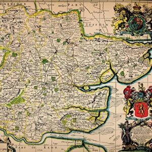
North America divided into its III principall [sic] parts, 1685. Creator: Philip Lea
![North America divided into its III principall [sic] parts, 1685. Creator: Philip Lea](/p/731/north-america-divided-iii-principall-sic-parts-35128787.jpg.webp "North America divided into its III principall [sic] parts, 1685. Creator: Philip Lea")
![]()
Wall Art and Photo Gifts from Heritage Images
North America divided into its III principall [sic] parts, 1685. Creator: Philip Lea
North America divided into its III principall [sic] parts, 1685. This map, North America Divided into its III Principal Parts, was created in the late 17th century and reflects the contemporary knowledge of North America and neighboring regions in the early colonial era. It was drafted in 1685 by the English cartographer Philip Lea, who made several maps of North America in the course of a career in which he produced a wide range of maps and atlases. Some parts of the map bear their modern names. Others have names that are colorfully descriptive, such as Tract of Land full of Wild Bulls, " "Mission of ye Recollect or Upstart Franciscan Friars, " and "Chooaskaby or Nation of Strong Men." The map contains the names of rivers, lakes, cities, colonies, mission sites, forts, Native American territories, and known mountain ranges. The map has grid lines but no scale."
Heritage Images features heritage image collections
Media ID 35128787
© Heritage Art/Heritage Images
1680s California United States Of America Cartographic Cartography Cities Colonies Colony Fort Lakes Map Making Mapmaking Mission Mountain Range New Mexico United States Of America New South Wales North America North American Rivers Territorial Territory Baroque Era Fortifications Meeting Of Frontiers
FEATURES IN THESE COLLECTIONS
> Animals
> Mammals
> Cricetidae
> California Mouse
> Animals
> Wild
> Related Images
> Arts
> Art Movements
> Baroque
> Arts
> Artists
> L
> Philip Lea
> Arts
> Contemporary art
> Modern art
> Arts
> Minimalist artwork
> Contemporary art
> Modern art
> Arts
> Modern art pieces
> Contemporary art
> Arts
> Pop art
> Contemporary art
> Modern art gallery
> Europe
> United Kingdom
> Wales
> Lakes
> Europe
> United Kingdom
> Wales
> Maps
EDITORS COMMENTS
This map print, titled "North America Divided into its III Principal Parts," dates back to the late 17th century and was created by the English cartographer Philip Lea in 1685. The map offers a fascinating glimpse into the contemporary understanding of North America and neighboring regions during the early colonial era. The map is divided into three principal parts: New England, New France, and New Spain. Each part is richly detailed, featuring the names of rivers, lakes, cities, colonies, mission sites, forts, Native American territories, and known mountain ranges. Some names on the map, such as Tract of Land full of Wild Bulls, Mission of ye Recollect or Upstart Franciscan Friars, and Chooaskaby or Nation of Strong Men, are colorfully descriptive and evoke the spirit of the era. Grid lines are present on the map but no scale is provided, reflecting the cartographic practices of the time. The map contains several notable features, including the names of major cities such as Boston, Quebec, and Mexico City, as well as colonies like New Britain (Hartford, Connecticut) and New Mexico. Fortifications, such as those in New France and New Spain, are also depicted, highlighting the military presence in the region. The map's intricate details and vibrant colors offer a window into the past, providing insights into the geography, culture, and history of North America during the Baroque era. The map is a valuable addition to any collection of historical maps or maps of North America, and is a testament to the rich heritage of cartography and exploration during the 17th century.
MADE IN THE USA
Safe Shipping with 30 Day Money Back Guarantee
FREE PERSONALISATION*
We are proud to offer a range of customisation features including Personalised Captions, Color Filters and Picture Zoom Tools
SECURE PAYMENTS
We happily accept a wide range of payment options so you can pay for the things you need in the way that is most convenient for you
* Options may vary by product and licensing agreement. Zoomed Pictures can be adjusted in the Cart.