Home > Arts > Artists > H > Henricus Hondius
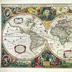
Map of parts of North Brabant, South Holland and Gelderland, 1629. Creator: Balthasar Florisz. van Berckenrode

![]()
Wall Art and Photo Gifts from Heritage Images
Map of parts of North Brabant, South Holland and Gelderland, 1629. Creator: Balthasar Florisz. van Berckenrode
Map of parts of North Brabant, South Holland and Gelderland, 1629. The surroundings of the Bies Bos, sailing ship. Bottom left a cartouche with the title with the scale in German miles (1: 100, 000)
Heritage Images features heritage image collections
Media ID 36338077
© Heritage Art/Heritage Images
Brabant Gelderland Watercolour Paint
FEATURES IN THESE COLLECTIONS
> Arts
> Artists
> H
> Henricus Hondius
> Europe
> Germany
> Lakes
> Related Images
> Europe
> Netherlands
> Lakes
> Related Images
> Europe
> Netherlands
> Maps
> Europe
> Netherlands
> Posters
> Europe
> Netherlands
> Related Images
> Maps and Charts
> Netherlands
EDITORS COMMENTS
This exquisite map print, created by the renowned Dutch cartographer Balthasar Florisz. van Berckenrode in 1629, showcases parts of the provinces North Brabant, South Holland, and Gelderland in the Netherlands. The intricate detail of the map is evident in the depiction of geographical features such as the Bies Bos forest, a large wooded area in the southeastern part of North Brabant, and the many bodies of water, including the Rhine and Meuse rivers. The map is adorned with a sailing ship in the lower right corner, adding a dynamic element to the otherwise static representation of the landscape. The map is a testament to the advanced cartographic techniques of the 17th century. It was produced using a combination of etching and watercolor, resulting in a richly detailed and colorful representation of the region. The cartouche at the bottom left of the map includes the title and the scale in German miles (1: 100,000). Balthasar Florisz. van Berckenrode was a prominent mapmaker of the Dutch Golden Age, known for his accurate and detailed maps. This map was likely produced in collaboration with Henricus Hondius, another prominent cartographer of the time. The map is now part of the collection of the Rijksmuseum in Amsterdam, and is a valuable addition to the museum's extensive collection of Dutch and European art and heritage.
MADE IN THE USA
Safe Shipping with 30 Day Money Back Guarantee
FREE PERSONALISATION*
We are proud to offer a range of customisation features including Personalised Captions, Color Filters and Picture Zoom Tools
SECURE PAYMENTS
We happily accept a wide range of payment options so you can pay for the things you need in the way that is most convenient for you
* Options may vary by product and licensing agreement. Zoomed Pictures can be adjusted in the Cart.