Home > Animals > Mammals > Cats (Domestic) > Russian White
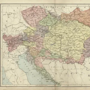
Map of the Frontiers of Austria & Russia, 1856. Creator: Unknown. Map of the Frontiers of Austria & Russia, 1856. Creator: Unknown

![]()
Wall Art and Photo Gifts from Heritage Images
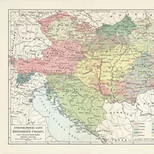
Map of the Frontiers of Austria & Russia, 1856. Creator: Unknown. Map of the Frontiers of Austria & Russia, 1856. Creator: Unknown
Map of the Frontiers of Austria & Russia, 1856. Map showing the area involved in the Crimean War: Black Sea, Transylvania, Hungary, Poland, Turkey, Odessa, Kiev, Bessarabia, Galicia, the Western Carpathian Mountains. From "Illustrated London News", 1856
Heritage Images features heritage image collections
Media ID 36337911
© /Heritage Images
Black Sea Border Borders Carpathians Coastline Crimean War Danube Frontier Frontiers Mountain Range Odessa Odessa Ukraine Poland Republic Of Hungary River Danube Siebenburgen Romania Europe Transylvania Carpathian Mountains
FEATURES IN THESE COLLECTIONS
> Animals
> Mammals
> Cats (Domestic)
> Russian White
> Asia
> Turkey
> Related Images
> Europe
> Austria
> Related Images
> Europe
> Hungary
> Related Images
EDITORS COMMENTS
This map print, titled 'Map of the Frontiers of Austria & Russia,' dates back to 1856, and its creator remains unknown. The map offers a detailed representation of the geographical features and political boundaries of Europe during the mid-19th century, with a particular focus on the areas involved in the Crimean War. The map illustrates the Black Sea and its coastal regions, including Odessa and Kiev in present-day Ukraine, as well as the Danube River and its tributaries. The Western Carpathian Mountains, stretching from present-day Slovakia to Romania, are also depicted in this intricately engraved map. The map's historical significance lies in its relevance to the Crimean War, which took place between 1853 and 1856, primarily between Russia and the Ottoman Empire, with major involvement from European powers such as Britain, France, and Austria. The map highlights the territories of Austria, Hungary, Poland, and Transylvania, which were significant players in the conflict. This map was originally published in the prestigious British newspaper, 'Illustrated London News,' providing valuable context to the geopolitical events of the time. The map's black and white contrast, characteristic of the era, adds to its antique charm and historical allure. The Map of the Frontiers of Austria & Russia, 1856, is an essential addition to any collection focusing on European history, cartography, or the Crimean War. Its intricate details and historical significance make it a fascinating glimpse into the past, offering insights into the geopolitical landscape of the 19th century.
MADE IN THE USA
Safe Shipping with 30 Day Money Back Guarantee
FREE PERSONALISATION*
We are proud to offer a range of customisation features including Personalised Captions, Color Filters and Picture Zoom Tools
FREE COLORIZATION SERVICE
You can choose advanced AI Colorization for this picture at no extra charge!
SECURE PAYMENTS
We happily accept a wide range of payment options so you can pay for the things you need in the way that is most convenient for you
* Options may vary by product and licensing agreement. Zoomed Pictures can be adjusted in the Cart.