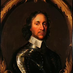
Home > Arts > Artists > W > Robert Walker
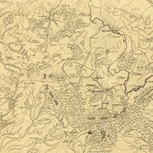
Map of the Battle of Saarbrücken, 2 August 1870, (c1872). Creator: R. Walker
. Creator: R. Walker")
![]()
Wall Art and Photo Gifts from Heritage Images
Map of the Battle of Saarbrücken, 2 August 1870, (c1872). Creator: R. Walker
Map of the Battle of Saarbrucken, 2 August 1870, (c1872). Map: Drawn under the Superintendance of Captain Hozier, showing the enemy positions. The town of Saarbrucken (in Germany) was the first target of the French invasion force during the Franco-Prussian War of 1870-1871. From " The Franco-Prussian War: its causes, incidents and consequences", Volume I, by Captain H M Hozier. [William Mackenzie, London, 1872]
Heritage Images features heritage image collections
Media ID 19780579
© The Print Collector/Heritage Images
1870 1871 Adversary Enemy Franco Prussian War Front Line Frontline H M Hozier Henry Montague Henry Montague Hozier Hozier Lines Mackenzie Prussia Prussian Prussian Army R Walker Robert Walker Sir Henry Montagu Hozier Walker William Mackenzie Battlefield Saarbrucken Saarland
FEATURES IN THESE COLLECTIONS
> Arts
> Artists
> W
> Robert Walker
> Europe
> United Kingdom
> England
> London
> Related Images
EDITORS COMMENTS
This print captures a historical moment in the Franco-Prussian War of 1870-1871. The image depicts a map of the Battle of Saarbrücken, which took place on 2 August 1870. Created by R. Walker and drawn under the superintendence of Captain Hozier, this map provides valuable insight into enemy positions during this significant conflict. Saarbrücken, located in Germany, was the initial target for the French invasion force. As seen in the map, it served as a crucial battleground where both French and Prussian armies clashed fiercely. This print offers a glimpse into the intense warfare that characterized this period. The detailed lines and markings on the map showcase strategic military planning and highlight key locations within Saarbrücken's battlefield. It serves as an essential resource for historians studying this era or anyone interested in understanding how armed forces operated during the late 19th century. The significance of this particular battle is further emphasized by its inclusion in Captain H M Hozier's book "The Franco-Prussian War: its causes, incidents and consequences". Published in London by William Mackenzie in 1872, Hozier's work sheds light on various aspects of this war. Overall, this print not only preserves an important historical document but also allows us to reflect upon past conflicts that have shaped our world today.
MADE IN THE USA
Safe Shipping with 30 Day Money Back Guarantee
FREE PERSONALISATION*
We are proud to offer a range of customisation features including Personalised Captions, Color Filters and Picture Zoom Tools
SECURE PAYMENTS
We happily accept a wide range of payment options so you can pay for the things you need in the way that is most convenient for you
* Options may vary by product and licensing agreement. Zoomed Pictures can be adjusted in the Cart.