Home > Historic > Battles > Battle of the Somme > Somme Offensive
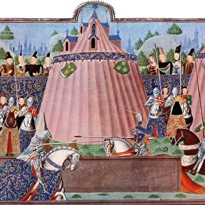
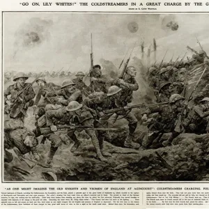
La guerre 13-19 juillet 1916; Nord et sud de la Somme: Croquis du terrain de l'offensive... 1916. Creator: Unknown

![]()
Wall Art and Photo Gifts from Heritage Images
La guerre 13-19 juillet 1916; Nord et sud de la Somme: Croquis du terrain de l'offensive... 1916. Creator: Unknown
La guerre 13-19 juillet 1916; Nord et sud de la Somme: Croquis du terrain de l'offensive franco-britannique commencee la 1er juillet. La partie grisee indique l'avance realisee a la date 19 juillet, 1916. From "Collection de la Guerre IV. L'Illustration Tome CXLVIII. La Guerre Juillet, Aout, Septembre, Octobre, Novembre, Decembre 1916"
Heritage Images features heritage image collections
Media ID 36340151
© The Print Collector/Heritage Images
Battle Of The Somme Conflict France Europe Lillustration Somme Front Somme Offensive Western Front Armed Services
FEATURES IN THESE COLLECTIONS
> Europe
> France
> Canton
> Nord
> Europe
> France
> Canton
> Somme
> Historic
> Battles
> Battle of the Somme
> Historical warfare
> Historic
> Battles
> Battle of the Somme
> Military history
> Historic
> Battles
> Battle of the Somme
> Somme Offensive
> Historic
> Battles
> Battle of the Somme
> Western Front battles
> Historic
> Battles
> Battle of the Somme
> Historic
> World War I and II
EDITORS COMMENTS
This black and white print, titled 'La guerre 13-19 juillet 1916; Nord et sud de la Somme: Croquis du terrain de l'offensive franco-britannique commencee la 1er juillet' (The War of 13-19 July 1916: Sketch of the Terrain of the Franco-British Offensive on the Somme Front, which began on July 1st), showcases an intricate and detailed map of the Somme Front during the major offensive that took place between July 13 and July 19, 1916. The print, which is part of the 'Collection de la Guerre IV. L'Illustration Tome CXLVIII. La Guerre Juillet, Aout, Septembre, Octobre, Novembre, Decembre 1916' (Collection IV. The Illustration Volume CXLVIII. The War July, August, September, October, November, December 1916), provides a unique insight into the strategic maneuvers and advancements of the French and British forces during the Battle of the Somme in World War I. The grey areas on the map represent the ground gained by the Allied forces up until July 19, 1916. This historical map serves as a poignant reminder of the significant events that unfolded during this pivotal moment in world history, and offers a glimpse into the complexities of the military strategies employed during the First World War.
MADE IN THE USA
Safe Shipping with 30 Day Money Back Guarantee
FREE PERSONALISATION*
We are proud to offer a range of customisation features including Personalised Captions, Color Filters and Picture Zoom Tools
SECURE PAYMENTS
We happily accept a wide range of payment options so you can pay for the things you need in the way that is most convenient for you
* Options may vary by product and licensing agreement. Zoomed Pictures can be adjusted in the Cart.